You are here: Home > Network List > TA - USArray Transportable Network (new EarthScope stations) Stations List
> Station W32A Sentinel, OK, USA > Earthquake Result Viewer
W32A Sentinel, OK, USA - Earthquake Result Viewer
| Earthquake location: |
Ecuador |
| Earthquake latitude/longitude: |
-1.8/-76.9 |
| Earthquake time(UTC): |
2011/08/15 (227) 02:53:18 GMT |
| Earthquake Depth: |
177 km |
| Earthquake Magnitude: |
5.7 MB, 5.7 MW, 5.7 MW |
| Earthquake Catalog/Contributor: |
WHDF/NEIC |
|
| Network: |
TA USArray Transportable Network (new EarthScope stations) |
| Station: |
W32A Sentinel, OK, USA |
| Lat/Lon: |
35.12 N/99.25 W |
| Elevation: |
494 m |
|
| Distance: |
42.3 deg |
| Az: |
332.415 deg |
| Baz: |
145.624 deg |
| Ray Param: |
0.07259932 |
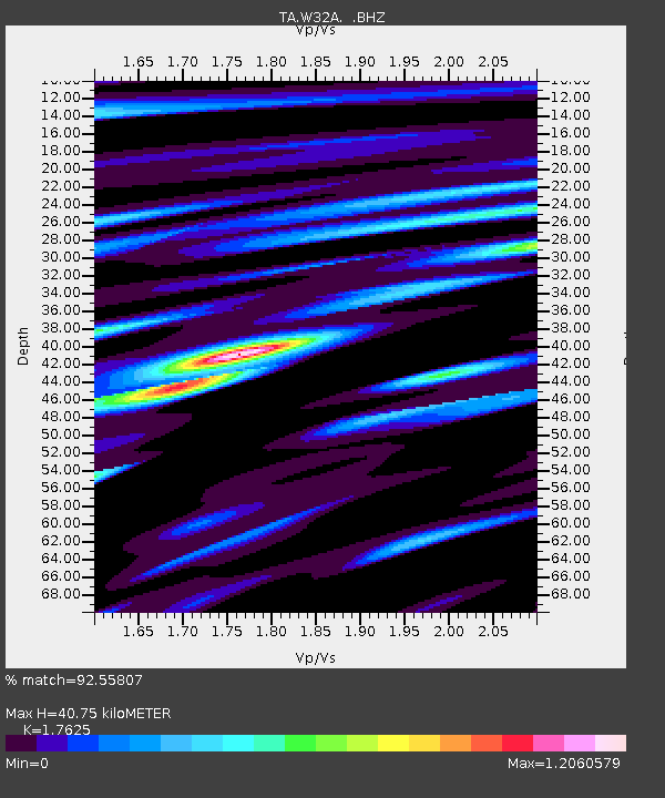
| Estimated Moho Depth: |
40.75 km |
| Estimated Crust Vp/Vs: |
1.76 |
| Assumed Crust Vp: |
6.315 km/s |
| Estimated Crust Vs: |
3.583 km/s |
| Estimated Crust Poisson's Ratio: |
0.26 |
|
| Radial Match: |
92.55807 % |
| Radial Bump: |
400 |
| Transverse Match: |
78.26531 % |
| Transverse Bump: |
400 |
| SOD ConfigId: |
410809 |
| Insert Time: |
2012-01-06 05:25:55.641 +0000 |
| GWidth: |
2.5 |
| Max Bumps: |
400 |
| Tol: |
0.001 |
|

Signal To Noise
| Channel | StoN | STA | LTA |
| TA:W32A: :BHZ:20110815T03:00:24.200009Z | 52.910904 | 3.6989786E-6 | 6.9909575E-8 |
| TA:W32A: :BHN:20110815T03:00:24.200009Z | 16.208794 | 1.0868941E-6 | 6.705583E-8 |
| TA:W32A: :BHE:20110815T03:00:24.200009Z | 6.533424 | 4.9095365E-7 | 7.514493E-8 |
| Arrivals |
| Ps | 5.2 SECOND |
| PpPs | 17 SECOND |
| PsPs/PpSs | 22 SECOND |


