You are here: Home > Network List > G - GEOSCOPE Stations List
> Station DRV Dumont d'Urville, Terre Adelie (Antartica) > Earthquake Result Viewer
DRV Dumont d'Urville, Terre Adelie (Antartica) - Earthquake Result Viewer

| Earthquake location: |
Vanuatu Islands |
| Earthquake latitude/longitude: |
-13.5/167.1 |
| Earthquake time(UTC): |
1996/06/10 (162) 01:04:46 GMT |
| Earthquake Depth: |
200 km |
| Earthquake Magnitude: |
5.8 MB, 5.9 MS, 6.7 UNKNOWN, 6.0 MS |
| Earthquake Catalog/Contributor: |
WHDF/NEIC |
|
| Network: |
G GEOSCOPE |
| Station: |
DRV Dumont d'Urville, Terre Adelie (Antartica) |
| Lat/Lon: |
66.67 S/140.01 E |
| Elevation: |
40 m |
|
| Distance: |
56.1 deg |
| Az: |
192.634 deg |
| Baz: |
32.284 deg |
| Ray Param: |
0.06367021 |
| Estimated Moho Depth: |
38.0 km |
| Estimated Crust Vp/Vs: |
1.71 |
| Assumed Crust Vp: |
6.39 km/s |
| Estimated Crust Vs: |
3.742 km/s |
| Estimated Crust Poisson's Ratio: |
0.24 |
|
| Radial Match: |
96.351875 % |
| Radial Bump: |
373 |
| Transverse Match: |
89.38686 % |
| Transverse Bump: |
400 |
| SOD ConfigId: |
6273 |
| Insert Time: |
2010-02-26 22:02:39.496 +0000 |
| GWidth: |
2.5 |
| Max Bumps: |
400 |
| Tol: |
0.001 |
|
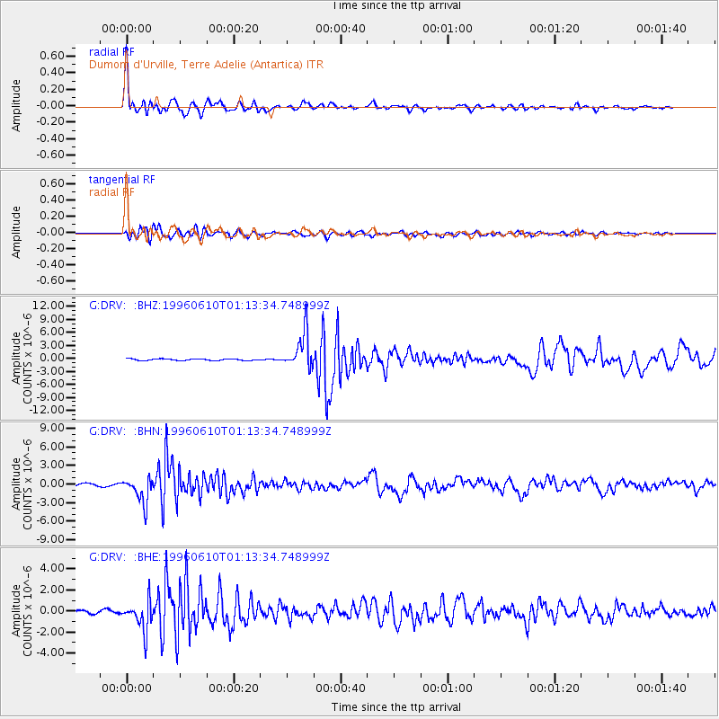
Signal To Noise
| Channel | StoN | STA | LTA |
| G:DRV: :BHN:19960610T01:13:34.748999Z | 10.604703 | 2.0649122E-6 | 1.9471665E-7 |
| G:DRV: :BHE:19960610T01:13:34.748999Z | 9.05996 | 1.4300139E-6 | 1.5783887E-7 |
| G:DRV: :BHZ:19960610T01:13:34.748999Z | 21.986786 | 4.2039424E-6 | 1.9120313E-7 |
| Arrivals |
| Ps | 4.4 SECOND |
| PpPs | 15 SECOND |
| PsPs/PpSs | 20 SECOND |


