You are here: Home > Network List > TA - USArray Transportable Network (new EarthScope stations) Stations List
> Station 334A Lometa, TX, USA > Earthquake Result Viewer
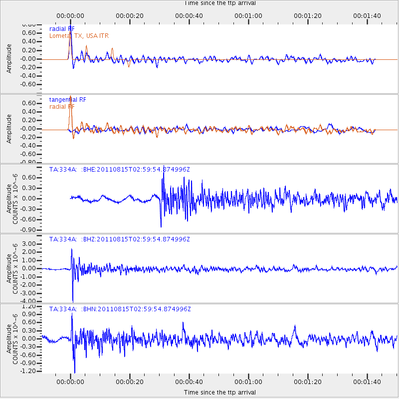
334A Lometa, TX, USA - Earthquake Result Viewer
*The percent match for this event was below the threshold and hence no stack was calculated.
| Earthquake location: |
Ecuador |
| Earthquake latitude/longitude: |
-1.8/-76.9 |
| Earthquake time(UTC): |
2011/08/15 (227) 02:53:18 GMT |
| Earthquake Depth: |
177 km |
| Earthquake Magnitude: |
5.7 MB, 5.7 MW, 5.7 MW |
| Earthquake Catalog/Contributor: |
WHDF/NEIC |
|
| Network: |
TA USArray Transportable Network (new EarthScope stations) |
| Station: |
334A Lometa, TX, USA |
| Lat/Lon: |
31.33 N/98.24 W |
| Elevation: |
389 m |
|
| Distance: |
38.7 deg |
| Az: |
330.145 deg |
| Baz: |
144.446 deg |
| Ray Param: |
$rayparam |
*The percent match for this event was below the threshold and hence was not used in the summary stack. |
|
| Radial Match: |
77.32573 % |
| Radial Bump: |
400 |
| Transverse Match: |
67.5685 % |
| Transverse Bump: |
400 |
| SOD ConfigId: |
410809 |
| Insert Time: |
2012-01-06 05:27:26.235 +0000 |
| GWidth: |
2.5 |
| Max Bumps: |
400 |
| Tol: |
0.001 |
|
Signal To Noise
| Channel | StoN | STA | LTA |
| TA:334A: :BHZ:20110815T02:59:54.874996Z | 15.3272085 | 1.0314473E-6 | 6.729518E-8 |
| TA:334A: :BHN:20110815T02:59:54.874996Z | 6.17167 | 3.751206E-7 | 6.0781055E-8 |
| TA:334A: :BHE:20110815T02:59:54.874996Z | 5.5825953 | 3.176335E-7 | 5.6897104E-8 |
| Arrivals |
| Ps | |
| PpPs | |
| PsPs/PpSs | |


