You are here: Home > Network List > TA - USArray Transportable Network (new EarthScope stations) Stations List
> Station 337A Centerville, TX, USA > Earthquake Result Viewer
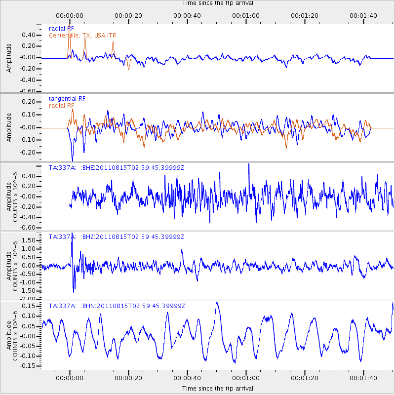
337A Centerville, TX, USA - Earthquake Result Viewer
*The percent match for this event was below the threshold and hence no stack was calculated.
| Earthquake location: |
Ecuador |
| Earthquake latitude/longitude: |
-1.8/-76.9 |
| Earthquake time(UTC): |
2011/08/15 (227) 02:53:18 GMT |
| Earthquake Depth: |
177 km |
| Earthquake Magnitude: |
5.7 MB, 5.7 MW, 5.7 MW |
| Earthquake Catalog/Contributor: |
WHDF/NEIC |
|
| Network: |
TA USArray Transportable Network (new EarthScope stations) |
| Station: |
337A Centerville, TX, USA |
| Lat/Lon: |
31.32 N/95.89 W |
| Elevation: |
150 m |
|
| Distance: |
37.6 deg |
| Az: |
332.836 deg |
| Baz: |
147.781 deg |
| Ray Param: |
$rayparam |
*The percent match for this event was below the threshold and hence was not used in the summary stack. |
|
| Radial Match: |
62.689564 % |
| Radial Bump: |
400 |
| Transverse Match: |
57.63817 % |
| Transverse Bump: |
400 |
| SOD ConfigId: |
410809 |
| Insert Time: |
2012-01-06 05:29:32.732 +0000 |
| GWidth: |
2.5 |
| Max Bumps: |
400 |
| Tol: |
0.001 |
|
Signal To Noise
| Channel | StoN | STA | LTA |
| TA:337A: :BHZ:20110815T02:59:45.39999Z | 7.717665 | 6.688503E-7 | 8.666485E-8 |
| TA:337A: :BHN:20110815T02:59:45.39999Z | 0.6639332 | 5.011032E-8 | 7.547494E-8 |
| TA:337A: :BHE:20110815T02:59:45.39999Z | 1.2113578 | 1.4751855E-7 | 1.2177951E-7 |
| Arrivals |
| Ps | |
| PpPs | |
| PsPs/PpSs | |


