You are here: Home > Network List > G - GEOSCOPE Stations List
> Station DRV Dumont d'Urville, Terre Adelie (Antartica) > Earthquake Result Viewer
DRV Dumont d'Urville, Terre Adelie (Antartica) - Earthquake Result Viewer
| Earthquake location: |
Flores Sea |
| Earthquake latitude/longitude: |
-7.1/122.6 |
| Earthquake time(UTC): |
1996/06/17 (169) 11:22:18 GMT |
| Earthquake Depth: |
587 km |
| Earthquake Magnitude: |
6.6 MB, 7.9 UNKNOWN, 7.8 MW |
| Earthquake Catalog/Contributor: |
WHDF/NEIC |
|
| Network: |
G GEOSCOPE |
| Station: |
DRV Dumont d'Urville, Terre Adelie (Antartica) |
| Lat/Lon: |
66.67 S/140.01 E |
| Elevation: |
40 m |
|
| Distance: |
60.6 deg |
| Az: |
172.135 deg |
| Baz: |
340.068 deg |
| Ray Param: |
0.05907829 |
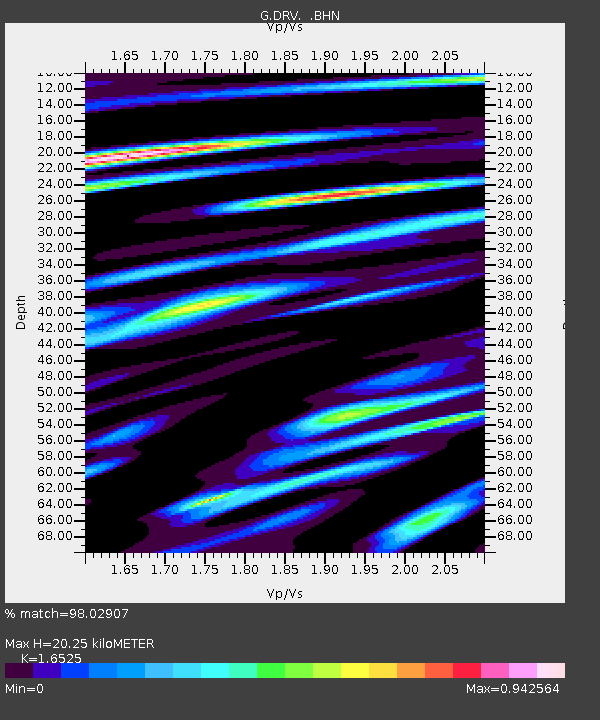
| Estimated Moho Depth: |
20.25 km |
| Estimated Crust Vp/Vs: |
1.65 |
| Assumed Crust Vp: |
6.39 km/s |
| Estimated Crust Vs: |
3.867 km/s |
| Estimated Crust Poisson's Ratio: |
0.21 |
|
| Radial Match: |
98.02907 % |
| Radial Bump: |
400 |
| Transverse Match: |
94.01913 % |
| Transverse Bump: |
400 |
| SOD ConfigId: |
6273 |
| Insert Time: |
2010-02-26 22:02:46.257 +0000 |
| GWidth: |
2.5 |
| Max Bumps: |
400 |
| Tol: |
0.001 |
|
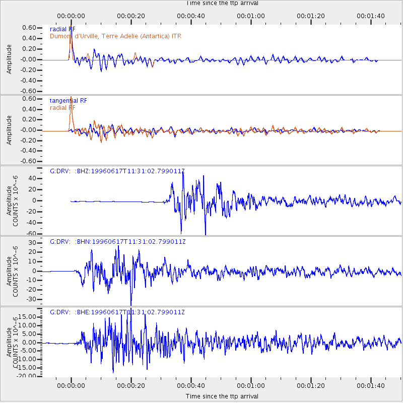
Signal To Noise
| Channel | StoN | STA | LTA |
| G:DRV: :BHN:19960617T11:31:02.799011Z | 31.872526 | 5.5001083E-6 | 1.725658E-7 |
| G:DRV: :BHE:19960617T11:31:02.799011Z | 14.327817 | 2.219953E-6 | 1.5494008E-7 |
| G:DRV: :BHZ:19960617T11:31:02.799011Z | 38.436504 | 1.1554582E-5 | 3.0061477E-7 |
| Arrivals |
| Ps | 2.2 SECOND |
| PpPs | 8.0 SECOND |
| PsPs/PpSs | 10 SECOND |


