You are here: Home > Network List > TA - USArray Transportable Network (new EarthScope stations) Stations List
> Station N34A Lincoln, NE, USA > Earthquake Result Viewer
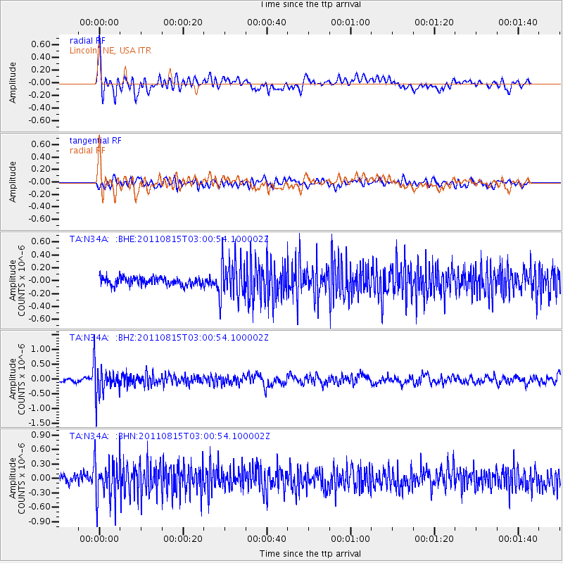
N34A Lincoln, NE, USA - Earthquake Result Viewer
*The percent match for this event was below the threshold and hence no stack was calculated.
| Earthquake location: |
Ecuador |
| Earthquake latitude/longitude: |
-1.8/-76.9 |
| Earthquake time(UTC): |
2011/08/15 (227) 02:53:18 GMT |
| Earthquake Depth: |
177 km |
| Earthquake Magnitude: |
5.7 MB, 5.7 MW, 5.7 MW |
| Earthquake Catalog/Contributor: |
WHDF/NEIC |
|
| Network: |
TA USArray Transportable Network (new EarthScope stations) |
| Station: |
N34A Lincoln, NE, USA |
| Lat/Lon: |
40.84 N/96.50 W |
| Elevation: |
401 m |
|
| Distance: |
46.1 deg |
| Az: |
339.307 deg |
| Baz: |
152.257 deg |
| Ray Param: |
$rayparam |
*The percent match for this event was below the threshold and hence was not used in the summary stack. |
|
| Radial Match: |
73.76282 % |
| Radial Bump: |
400 |
| Transverse Match: |
57.90841 % |
| Transverse Bump: |
400 |
| SOD ConfigId: |
410809 |
| Insert Time: |
2012-01-06 05:33:54.635 +0000 |
| GWidth: |
2.5 |
| Max Bumps: |
400 |
| Tol: |
0.001 |
|
Signal To Noise
| Channel | StoN | STA | LTA |
| TA:N34A: :BHZ:20110815T03:00:54.100002Z | 6.878713 | 4.3996766E-7 | 6.396075E-8 |
| TA:N34A: :BHN:20110815T03:00:54.100002Z | 5.6398993 | 4.00096E-7 | 7.0940274E-8 |
| TA:N34A: :BHE:20110815T03:00:54.100002Z | 4.888136 | 2.9453736E-7 | 6.025556E-8 |
| Arrivals |
| Ps | |
| PpPs | |
| PsPs/PpSs | |


