You are here: Home > Network List > TA - USArray Transportable Network (new EarthScope stations) Stations List
> Station U35A Pawnee, OK, USA > Earthquake Result Viewer
U35A Pawnee, OK, USA - Earthquake Result Viewer
| Earthquake location: |
Ecuador |
| Earthquake latitude/longitude: |
-1.8/-76.9 |
| Earthquake time(UTC): |
2011/08/15 (227) 02:53:18 GMT |
| Earthquake Depth: |
177 km |
| Earthquake Magnitude: |
5.7 MB, 5.7 MW, 5.7 MW |
| Earthquake Catalog/Contributor: |
WHDF/NEIC |
|
| Network: |
TA USArray Transportable Network (new EarthScope stations) |
| Station: |
U35A Pawnee, OK, USA |
| Lat/Lon: |
36.37 N/96.73 W |
| Elevation: |
303 m |
|
| Distance: |
42.2 deg |
| Az: |
335.974 deg |
| Baz: |
149.721 deg |
| Ray Param: |
0.07262609 |
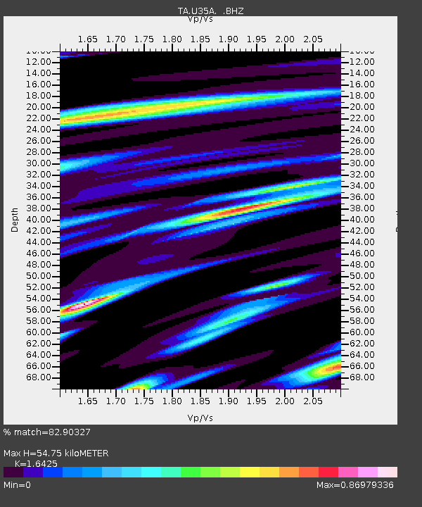
| Estimated Moho Depth: |
54.75 km |
| Estimated Crust Vp/Vs: |
1.64 |
| Assumed Crust Vp: |
6.483 km/s |
| Estimated Crust Vs: |
3.947 km/s |
| Estimated Crust Poisson's Ratio: |
0.21 |
|
| Radial Match: |
82.90327 % |
| Radial Bump: |
400 |
| Transverse Match: |
66.898094 % |
| Transverse Bump: |
400 |
| SOD ConfigId: |
410809 |
| Insert Time: |
2012-01-06 05:35:44.842 +0000 |
| GWidth: |
2.5 |
| Max Bumps: |
400 |
| Tol: |
0.001 |
|
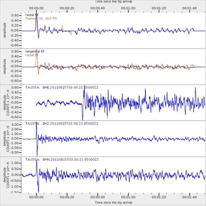
Signal To Noise
| Channel | StoN | STA | LTA |
| TA:U35A: :BHZ:20110815T03:00:23.850002Z | 14.626251 | 1.1905404E-6 | 8.13975E-8 |
| TA:U35A: :BHN:20110815T03:00:23.850002Z | 7.9385867 | 5.2101166E-7 | 6.5630275E-8 |
| TA:U35A: :BHE:20110815T03:00:23.850002Z | 5.5057206 | 2.8519807E-7 | 5.1800317E-8 |
| Arrivals |
| Ps | 5.8 SECOND |
| PpPs | 21 SECOND |
| PsPs/PpSs | 27 SECOND |


