You are here: Home > Network List > TA - USArray Transportable Network (new EarthScope stations) Stations List
> Station K35A Storm Lake, IA, USA > Earthquake Result Viewer
K35A Storm Lake, IA, USA - Earthquake Result Viewer
| Earthquake location: |
Ecuador |
| Earthquake latitude/longitude: |
-1.8/-76.9 |
| Earthquake time(UTC): |
2011/08/15 (227) 02:53:18 GMT |
| Earthquake Depth: |
177 km |
| Earthquake Magnitude: |
5.7 MB, 5.7 MW, 5.7 MW |
| Earthquake Catalog/Contributor: |
WHDF/NEIC |
|
| Network: |
TA USArray Transportable Network (new EarthScope stations) |
| Station: |
K35A Storm Lake, IA, USA |
| Lat/Lon: |
42.72 N/95.23 W |
| Elevation: |
439 m |
|
| Distance: |
47.3 deg |
| Az: |
341.628 deg |
| Baz: |
154.692 deg |
| Ray Param: |
0.06943182 |
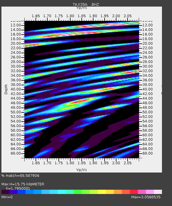
| Estimated Moho Depth: |
15.75 km |
| Estimated Crust Vp/Vs: |
1.80 |
| Assumed Crust Vp: |
6.53 km/s |
| Estimated Crust Vs: |
3.638 km/s |
| Estimated Crust Poisson's Ratio: |
0.27 |
|
| Radial Match: |
88.587906 % |
| Radial Bump: |
400 |
| Transverse Match: |
76.06964 % |
| Transverse Bump: |
400 |
| SOD ConfigId: |
410809 |
| Insert Time: |
2012-01-06 05:37:13.449 +0000 |
| GWidth: |
2.5 |
| Max Bumps: |
400 |
| Tol: |
0.001 |
|
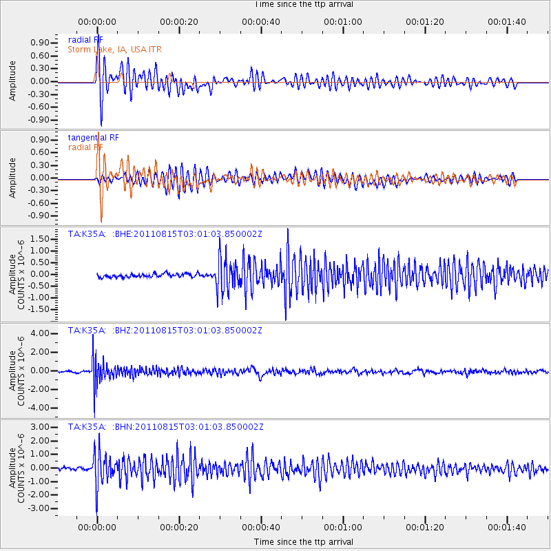
Signal To Noise
| Channel | StoN | STA | LTA |
| TA:K35A: :BHZ:20110815T03:01:03.850002Z | 23.050526 | 1.3367827E-6 | 5.7993592E-8 |
| TA:K35A: :BHN:20110815T03:01:03.850002Z | 15.649629 | 1.2001344E-6 | 7.6687726E-8 |
| TA:K35A: :BHE:20110815T03:01:03.850002Z | 9.509346 | 6.933048E-7 | 7.290773E-8 |
| Arrivals |
| Ps | 2.0 SECOND |
| PpPs | 6.3 SECOND |
| PsPs/PpSs | 8.4 SECOND |


