You are here: Home > Network List > TA - USArray Transportable Network (new EarthScope stations) Stations List
> Station J34A George, IA, USA > Earthquake Result Viewer
J34A George, IA, USA - Earthquake Result Viewer
*The percent match for this event was below the threshold and hence no stack was calculated.
| Earthquake location: |
Ecuador |
| Earthquake latitude/longitude: |
-1.8/-76.9 |
| Earthquake time(UTC): |
2011/08/15 (227) 02:53:18 GMT |
| Earthquake Depth: |
177 km |
| Earthquake Magnitude: |
5.7 MB, 5.7 MW, 5.7 MW |
| Earthquake Catalog/Contributor: |
WHDF/NEIC |
|
| Network: |
TA USArray Transportable Network (new EarthScope stations) |
| Station: |
J34A George, IA, USA |
| Lat/Lon: |
43.28 N/95.96 W |
| Elevation: |
432 m |
|
| Distance: |
48.1 deg |
| Az: |
341.309 deg |
| Baz: |
153.984 deg |
| Ray Param: |
$rayparam |
*The percent match for this event was below the threshold and hence was not used in the summary stack. |
|
| Radial Match: |
52.52197 % |
| Radial Bump: |
400 |
| Transverse Match: |
65.26497 % |
| Transverse Bump: |
400 |
| SOD ConfigId: |
410809 |
| Insert Time: |
2012-01-06 05:37:26.220 +0000 |
| GWidth: |
2.5 |
| Max Bumps: |
400 |
| Tol: |
0.001 |
|
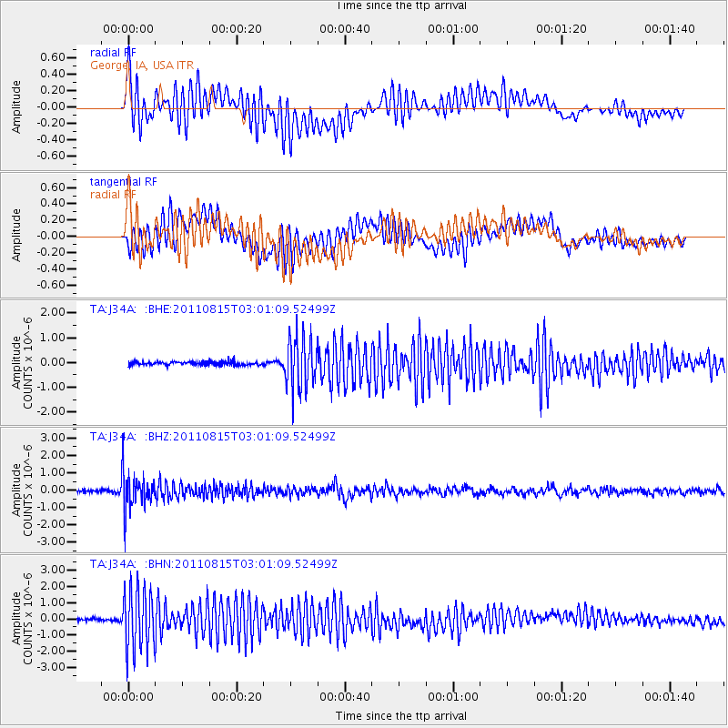
Signal To Noise
| Channel | StoN | STA | LTA |
| TA:J34A: :BHZ:20110815T03:01:09.52499Z | 11.48025 | 1.0237883E-6 | 8.917822E-8 |
| TA:J34A: :BHN:20110815T03:01:09.52499Z | 20.462086 | 1.901639E-6 | 9.293476E-8 |
| TA:J34A: :BHE:20110815T03:01:09.52499Z | 14.45699 | 1.0639338E-6 | 7.3593036E-8 |
| Arrivals |
| Ps | |
| PpPs | |
| PsPs/PpSs | |


