You are here: Home > Network List > TA - USArray Transportable Network (new EarthScope stations) Stations List
> Station G35A Watkins, MN, USA > Earthquake Result Viewer
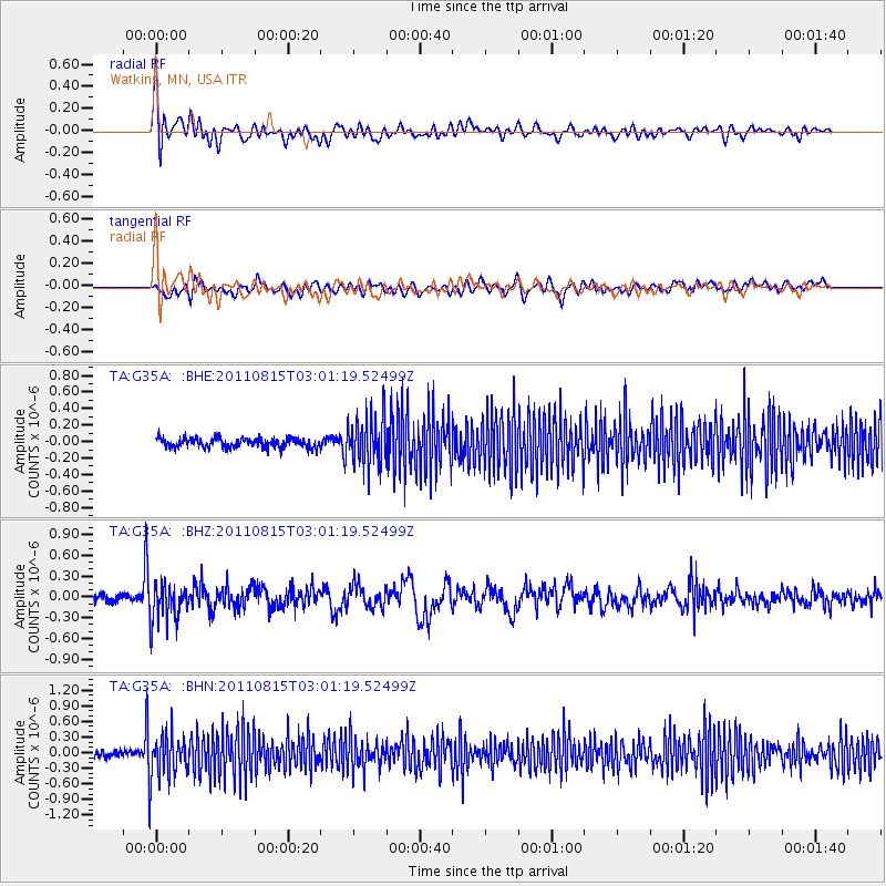
G35A Watkins, MN, USA - Earthquake Result Viewer
*The percent match for this event was below the threshold and hence no stack was calculated.
| Earthquake location: |
Ecuador |
| Earthquake latitude/longitude: |
-1.8/-76.9 |
| Earthquake time(UTC): |
2011/08/15 (227) 02:53:18 GMT |
| Earthquake Depth: |
177 km |
| Earthquake Magnitude: |
5.7 MB, 5.7 MW, 5.7 MW |
| Earthquake Catalog/Contributor: |
WHDF/NEIC |
|
| Network: |
TA USArray Transportable Network (new EarthScope stations) |
| Station: |
G35A Watkins, MN, USA |
| Lat/Lon: |
45.22 N/94.49 W |
| Elevation: |
361 m |
|
| Distance: |
49.4 deg |
| Az: |
343.665 deg |
| Baz: |
156.563 deg |
| Ray Param: |
$rayparam |
*The percent match for this event was below the threshold and hence was not used in the summary stack. |
|
| Radial Match: |
64.500084 % |
| Radial Bump: |
400 |
| Transverse Match: |
48.955063 % |
| Transverse Bump: |
400 |
| SOD ConfigId: |
410809 |
| Insert Time: |
2012-01-06 05:41:58.553 +0000 |
| GWidth: |
2.5 |
| Max Bumps: |
400 |
| Tol: |
0.001 |
|
Signal To Noise
| Channel | StoN | STA | LTA |
| TA:G35A: :BHZ:20110815T03:01:19.52499Z | 3.900427 | 2.7254706E-7 | 6.987621E-8 |
| TA:G35A: :BHN:20110815T03:01:19.52499Z | 7.0370097 | 4.389693E-7 | 6.238009E-8 |
| TA:G35A: :BHE:20110815T03:01:19.52499Z | 5.2061977 | 2.9270748E-7 | 5.6222888E-8 |
| Arrivals |
| Ps | |
| PpPs | |
| PsPs/PpSs | |


