You are here: Home > Network List > TA - USArray Transportable Network (new EarthScope stations) Stations List
> Station O37A Wolven Farm, McFall, MO, USA > Earthquake Result Viewer
O37A Wolven Farm, McFall, MO, USA - Earthquake Result Viewer
| Earthquake location: |
Ecuador |
| Earthquake latitude/longitude: |
-1.8/-76.9 |
| Earthquake time(UTC): |
2011/08/15 (227) 02:53:18 GMT |
| Earthquake Depth: |
177 km |
| Earthquake Magnitude: |
5.7 MB, 5.7 MW, 5.7 MW |
| Earthquake Catalog/Contributor: |
WHDF/NEIC |
|
| Network: |
TA USArray Transportable Network (new EarthScope stations) |
| Station: |
O37A Wolven Farm, McFall, MO, USA |
| Lat/Lon: |
40.17 N/94.15 W |
| Elevation: |
284 m |
|
| Distance: |
44.7 deg |
| Az: |
341.15 deg |
| Baz: |
155.076 deg |
| Ray Param: |
0.071101256 |
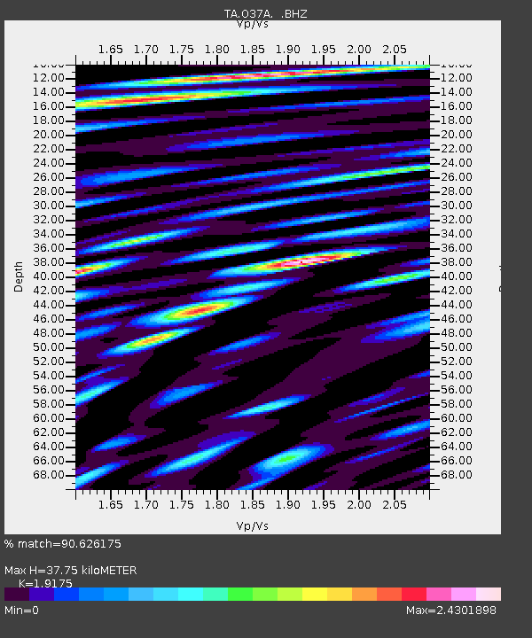
| Estimated Moho Depth: |
37.75 km |
| Estimated Crust Vp/Vs: |
1.92 |
| Assumed Crust Vp: |
6.498 km/s |
| Estimated Crust Vs: |
3.389 km/s |
| Estimated Crust Poisson's Ratio: |
0.31 |
|
| Radial Match: |
90.626175 % |
| Radial Bump: |
400 |
| Transverse Match: |
81.01021 % |
| Transverse Bump: |
400 |
| SOD ConfigId: |
410809 |
| Insert Time: |
2012-01-06 05:45:01.269 +0000 |
| GWidth: |
2.5 |
| Max Bumps: |
400 |
| Tol: |
0.001 |
|
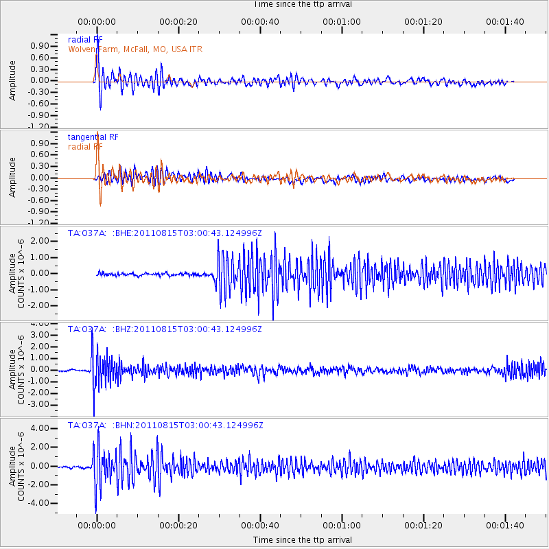
Signal To Noise
| Channel | StoN | STA | LTA |
| TA:O37A: :BHZ:20110815T03:00:43.124996Z | 18.051584 | 1.3308262E-6 | 7.3723506E-8 |
| TA:O37A: :BHN:20110815T03:00:43.124996Z | 28.52616 | 1.9311553E-6 | 6.76977E-8 |
| TA:O37A: :BHE:20110815T03:00:43.124996Z | 15.419172 | 1.0717949E-6 | 6.9510534E-8 |
| Arrivals |
| Ps | 5.7 SECOND |
| PpPs | 16 SECOND |
| PsPs/PpSs | 22 SECOND |


