You are here: Home > Network List > G - GEOSCOPE Stations List
> Station DRV Dumont d'Urville, Terre Adelie (Antartica) > Earthquake Result Viewer
DRV Dumont d'Urville, Terre Adelie (Antartica) - Earthquake Result Viewer
| Earthquake location: |
Kermadec Islands Region |
| Earthquake latitude/longitude: |
-31.8/-179.4 |
| Earthquake time(UTC): |
1997/05/03 (123) 16:46:02 GMT |
| Earthquake Depth: |
108 km |
| Earthquake Magnitude: |
6.6 MB, 6.9 UNKNOWN, 6.8 ME |
| Earthquake Catalog/Contributor: |
WHDF/NEIC |
|
| Network: |
G GEOSCOPE |
| Station: |
DRV Dumont d'Urville, Terre Adelie (Antartica) |
| Lat/Lon: |
66.67 S/140.01 E |
| Elevation: |
40 m |
|
| Distance: |
42.4 deg |
| Az: |
202.612 deg |
| Baz: |
55.276 deg |
| Ray Param: |
0.07282737 |
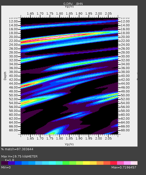
| Estimated Moho Depth: |
19.75 km |
| Estimated Crust Vp/Vs: |
1.80 |
| Assumed Crust Vp: |
6.39 km/s |
| Estimated Crust Vs: |
3.55 km/s |
| Estimated Crust Poisson's Ratio: |
0.28 |
|
| Radial Match: |
97.383644 % |
| Radial Bump: |
238 |
| Transverse Match: |
86.76265 % |
| Transverse Bump: |
400 |
| SOD ConfigId: |
6273 |
| Insert Time: |
2010-02-26 22:03:21.413 +0000 |
| GWidth: |
2.5 |
| Max Bumps: |
400 |
| Tol: |
0.001 |
|
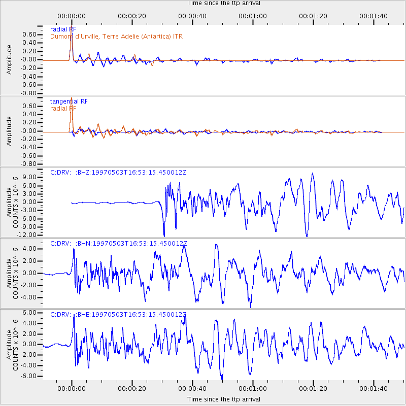
Signal To Noise
| Channel | StoN | STA | LTA |
| G:DRV: :BHN:19970503T16:53:15.450012Z | 11.707753 | 1.7985075E-6 | 1.5361678E-7 |
| G:DRV: :BHE:19970503T16:53:15.450012Z | 14.610848 | 2.3390473E-6 | 1.6008977E-7 |
| G:DRV: :BHZ:19970503T16:53:15.450012Z | 31.234604 | 5.106779E-6 | 1.6349749E-7 |
| Arrivals |
| Ps | 2.6 SECOND |
| PpPs | 8.1 SECOND |
| PsPs/PpSs | 11 SECOND |


