You are here: Home > Network List > TA - USArray Transportable Network (new EarthScope stations) Stations List
> Station 243A Waterproof, LA, USA > Earthquake Result Viewer
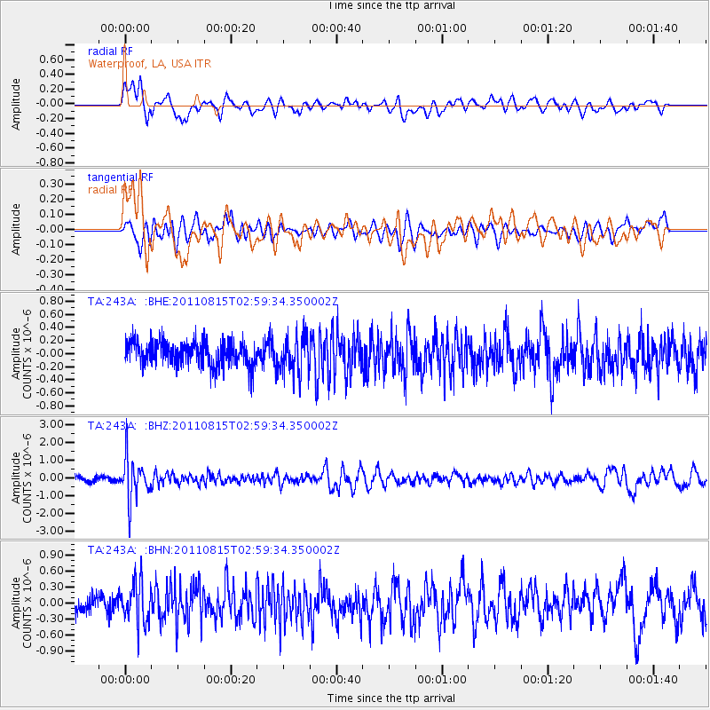
243A Waterproof, LA, USA - Earthquake Result Viewer
*The percent match for this event was below the threshold and hence no stack was calculated.
| Earthquake location: |
Ecuador |
| Earthquake latitude/longitude: |
-1.8/-76.9 |
| Earthquake time(UTC): |
2011/08/15 (227) 02:53:18 GMT |
| Earthquake Depth: |
177 km |
| Earthquake Magnitude: |
5.7 MB, 5.7 MW, 5.7 MW |
| Earthquake Catalog/Contributor: |
WHDF/NEIC |
|
| Network: |
TA USArray Transportable Network (new EarthScope stations) |
| Station: |
243A Waterproof, LA, USA |
| Lat/Lon: |
31.88 N/91.48 W |
| Elevation: |
2.0 m |
|
| Distance: |
36.3 deg |
| Az: |
338.775 deg |
| Baz: |
154.828 deg |
| Ray Param: |
$rayparam |
*The percent match for this event was below the threshold and hence was not used in the summary stack. |
|
| Radial Match: |
65.30692 % |
| Radial Bump: |
400 |
| Transverse Match: |
54.052765 % |
| Transverse Bump: |
400 |
| SOD ConfigId: |
410809 |
| Insert Time: |
2012-01-06 05:49:45.890 +0000 |
| GWidth: |
2.5 |
| Max Bumps: |
400 |
| Tol: |
0.001 |
|
Signal To Noise
| Channel | StoN | STA | LTA |
| TA:243A: :BHZ:20110815T02:59:34.350002Z | 8.325429 | 1.1737772E-6 | 1.4098698E-7 |
| TA:243A: :BHN:20110815T02:59:34.350002Z | 2.2563465 | 3.890647E-7 | 1.7243127E-7 |
| TA:243A: :BHE:20110815T02:59:34.350002Z | 1.5696347 | 2.8673114E-7 | 1.8267382E-7 |
| Arrivals |
| Ps | |
| PpPs | |
| PsPs/PpSs | |


