You are here: Home > Network List > TA - USArray Transportable Network (new EarthScope stations) Stations List
> Station W41B Gary Mavity, Velonia, AR, USA > Earthquake Result Viewer
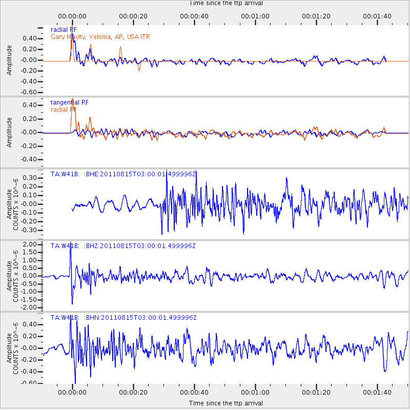
W41B Gary Mavity, Velonia, AR, USA - Earthquake Result Viewer
*The percent match for this event was below the threshold and hence no stack was calculated.
| Earthquake location: |
Ecuador |
| Earthquake latitude/longitude: |
-1.8/-76.9 |
| Earthquake time(UTC): |
2011/08/15 (227) 02:53:18 GMT |
| Earthquake Depth: |
177 km |
| Earthquake Magnitude: |
5.7 MB, 5.7 MW, 5.7 MW |
| Earthquake Catalog/Contributor: |
WHDF/NEIC |
|
| Network: |
TA USArray Transportable Network (new EarthScope stations) |
| Station: |
W41B Gary Mavity, Velonia, AR, USA |
| Lat/Lon: |
35.17 N/92.25 W |
| Elevation: |
95 m |
|
| Distance: |
39.5 deg |
| Az: |
340.08 deg |
| Baz: |
155.437 deg |
| Ray Param: |
$rayparam |
*The percent match for this event was below the threshold and hence was not used in the summary stack. |
|
| Radial Match: |
71.32313 % |
| Radial Bump: |
400 |
| Transverse Match: |
50.39386 % |
| Transverse Bump: |
400 |
| SOD ConfigId: |
410809 |
| Insert Time: |
2012-01-06 05:52:30.254 +0000 |
| GWidth: |
2.5 |
| Max Bumps: |
400 |
| Tol: |
0.001 |
|
Signal To Noise
| Channel | StoN | STA | LTA |
| TA:W41B: :BHZ:20110815T03:00:01.499996Z | 14.168296 | 7.342462E-7 | 5.1823186E-8 |
| TA:W41B: :BHN:20110815T03:00:01.499996Z | 4.968764 | 2.6195076E-7 | 5.2719507E-8 |
| TA:W41B: :BHE:20110815T03:00:01.499996Z | 3.5450928 | 1.5805588E-7 | 4.458441E-8 |
| Arrivals |
| Ps | |
| PpPs | |
| PsPs/PpSs | |


