You are here: Home > Network List > TA - USArray Transportable Network (new EarthScope stations) Stations List
> Station Y46A Houston, MS, USA > Earthquake Result Viewer
Y46A Houston, MS, USA - Earthquake Result Viewer
| Earthquake location: |
Ecuador |
| Earthquake latitude/longitude: |
-1.8/-76.9 |
| Earthquake time(UTC): |
2011/08/15 (227) 02:53:18 GMT |
| Earthquake Depth: |
177 km |
| Earthquake Magnitude: |
5.7 MB, 5.7 MW, 5.7 MW |
| Earthquake Catalog/Contributor: |
WHDF/NEIC |
|
| Network: |
TA USArray Transportable Network (new EarthScope stations) |
| Station: |
Y46A Houston, MS, USA |
| Lat/Lon: |
33.88 N/88.86 W |
| Elevation: |
109 m |
|
| Distance: |
37.2 deg |
| Az: |
343.466 deg |
| Baz: |
160.006 deg |
| Ray Param: |
0.07558417 |
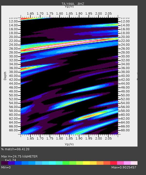
| Estimated Moho Depth: |
24.75 km |
| Estimated Crust Vp/Vs: |
1.74 |
| Assumed Crust Vp: |
6.201 km/s |
| Estimated Crust Vs: |
3.564 km/s |
| Estimated Crust Poisson's Ratio: |
0.25 |
|
| Radial Match: |
86.4128 % |
| Radial Bump: |
376 |
| Transverse Match: |
69.292336 % |
| Transverse Bump: |
391 |
| SOD ConfigId: |
410809 |
| Insert Time: |
2012-01-06 05:53:34.641 +0000 |
| GWidth: |
2.5 |
| Max Bumps: |
400 |
| Tol: |
0.001 |
|
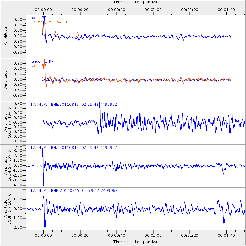
Signal To Noise
| Channel | StoN | STA | LTA |
| TA:Y46A: :BHZ:20110815T02:59:42.749996Z | 30.834265 | 1.2833469E-6 | 4.1620805E-8 |
| TA:Y46A: :BHN:20110815T02:59:42.749996Z | 7.826379 | 8.2643766E-7 | 1.0559643E-7 |
| TA:Y46A: :BHE:20110815T02:59:42.749996Z | 4.689447 | 3.303796E-7 | 7.045172E-8 |
| Arrivals |
| Ps | 3.2 SECOND |
| PpPs | 10 SECOND |
| PsPs/PpSs | 13 SECOND |


