You are here: Home > Network List > TA - USArray Transportable Network (new EarthScope stations) Stations List
> Station Z43A Armstrong Family, Eudora, AR, USA > Earthquake Result Viewer
Z43A Armstrong Family, Eudora, AR, USA - Earthquake Result Viewer
| Earthquake location: |
Ecuador |
| Earthquake latitude/longitude: |
-1.8/-76.9 |
| Earthquake time(UTC): |
2011/08/15 (227) 02:53:18 GMT |
| Earthquake Depth: |
177 km |
| Earthquake Magnitude: |
5.7 MB, 5.7 MW, 5.7 MW |
| Earthquake Catalog/Contributor: |
WHDF/NEIC |
|
| Network: |
TA USArray Transportable Network (new EarthScope stations) |
| Station: |
Z43A Armstrong Family, Eudora, AR, USA |
| Lat/Lon: |
33.21 N/91.24 W |
| Elevation: |
39 m |
|
| Distance: |
37.4 deg |
| Az: |
340.002 deg |
| Baz: |
155.938 deg |
| Ray Param: |
0.07551263 |
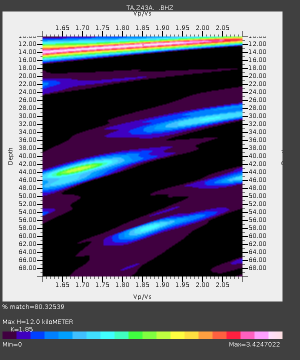
| Estimated Moho Depth: |
12.0 km |
| Estimated Crust Vp/Vs: |
1.85 |
| Assumed Crust Vp: |
6.201 km/s |
| Estimated Crust Vs: |
3.352 km/s |
| Estimated Crust Poisson's Ratio: |
0.29 |
|
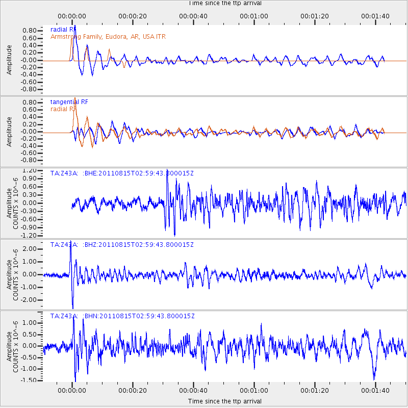
| Radial Match: |
80.32539 % |
| Radial Bump: |
400 |
| Transverse Match: |
71.34895 % |
| Transverse Bump: |
400 |
| SOD ConfigId: |
410809 |
| Insert Time: |
2012-01-06 05:55:20.516 +0000 |
| GWidth: |
2.5 |
| Max Bumps: |
400 |
| Tol: |
0.001 |
|
Signal To Noise
| Channel | StoN | STA | LTA |
| TA:Z43A: :BHZ:20110815T02:59:43.800015Z | 13.089236 | 1.0419536E-6 | 7.960385E-8 |
| TA:Z43A: :BHN:20110815T02:59:43.800015Z | 4.7665186 | 6.328965E-7 | 1.3277962E-7 |
| TA:Z43A: :BHE:20110815T02:59:43.800015Z | 3.7766993 | 5.246017E-7 | 1.3890481E-7 |
| Arrivals |
| Ps | 1.8 SECOND |
| PpPs | 5.2 SECOND |
| PsPs/PpSs | 6.9 SECOND |


