You are here: Home > Network List > TA - USArray Transportable Network (new EarthScope stations) Stations List
> Station V44A Blytheville, AR, USA > Earthquake Result Viewer
V44A Blytheville, AR, USA - Earthquake Result Viewer
*The percent match for this event was below the threshold and hence no stack was calculated.
| Earthquake location: |
Ecuador |
| Earthquake latitude/longitude: |
-1.8/-76.9 |
| Earthquake time(UTC): |
2011/08/15 (227) 02:53:18 GMT |
| Earthquake Depth: |
177 km |
| Earthquake Magnitude: |
5.7 MB, 5.7 MW, 5.7 MW |
| Earthquake Catalog/Contributor: |
WHDF/NEIC |
|
| Network: |
TA USArray Transportable Network (new EarthScope stations) |
| Station: |
V44A Blytheville, AR, USA |
| Lat/Lon: |
35.83 N/89.90 W |
| Elevation: |
78 m |
|
| Distance: |
39.4 deg |
| Az: |
343.265 deg |
| Baz: |
159.258 deg |
| Ray Param: |
$rayparam |
*The percent match for this event was below the threshold and hence was not used in the summary stack. |
|
| Radial Match: |
78.60258 % |
| Radial Bump: |
400 |
| Transverse Match: |
63.507874 % |
| Transverse Bump: |
400 |
| SOD ConfigId: |
410809 |
| Insert Time: |
2012-01-06 05:57:20.406 +0000 |
| GWidth: |
2.5 |
| Max Bumps: |
400 |
| Tol: |
0.001 |
|
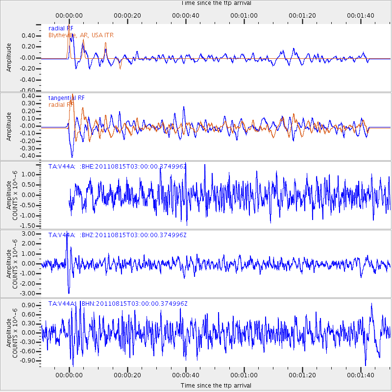
Signal To Noise
| Channel | StoN | STA | LTA |
| TA:V44A: :BHZ:20110815T03:00:00.374996Z | 6.1498876 | 1.309507E-6 | 2.1293187E-7 |
| TA:V44A: :BHN:20110815T03:00:00.374996Z | 2.827023 | 5.153186E-7 | 1.8228313E-7 |
| TA:V44A: :BHE:20110815T03:00:00.374996Z | 1.4262767 | 5.502578E-7 | 3.8580018E-7 |
| Arrivals |
| Ps | |
| PpPs | |
| PsPs/PpSs | |


