You are here: Home > Network List > G - GEOSCOPE Stations List
> Station DRV Dumont d'Urville, Terre Adelie (Antartica) > Earthquake Result Viewer
DRV Dumont d'Urville, Terre Adelie (Antartica) - Earthquake Result Viewer
| Earthquake location: |
Halmahera, Indonesia |
| Earthquake latitude/longitude: |
-1.9/127.9 |
| Earthquake time(UTC): |
1997/06/24 (175) 23:04:53 GMT |
| Earthquake Depth: |
33 km |
| Earthquake Magnitude: |
5.9 MB, 6.1 MS, 6.4 UNKNOWN, 6.1 MS |
| Earthquake Catalog/Contributor: |
WHDF/NEIC |
|
| Network: |
G GEOSCOPE |
| Station: |
DRV Dumont d'Urville, Terre Adelie (Antartica) |
| Lat/Lon: |
66.67 S/140.01 E |
| Elevation: |
40 m |
|
| Distance: |
65.2 deg |
| Az: |
174.716 deg |
| Baz: |
346.642 deg |
| Ray Param: |
0.058391936 |
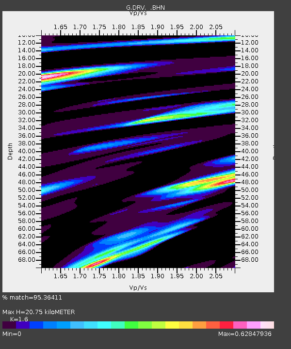
| Estimated Moho Depth: |
20.75 km |
| Estimated Crust Vp/Vs: |
1.60 |
| Assumed Crust Vp: |
6.39 km/s |
| Estimated Crust Vs: |
3.994 km/s |
| Estimated Crust Poisson's Ratio: |
0.18 |
|
| Radial Match: |
95.36411 % |
| Radial Bump: |
400 |
| Transverse Match: |
86.55876 % |
| Transverse Bump: |
400 |
| SOD ConfigId: |
6273 |
| Insert Time: |
2010-02-26 22:03:33.082 +0000 |
| GWidth: |
2.5 |
| Max Bumps: |
400 |
| Tol: |
0.001 |
|
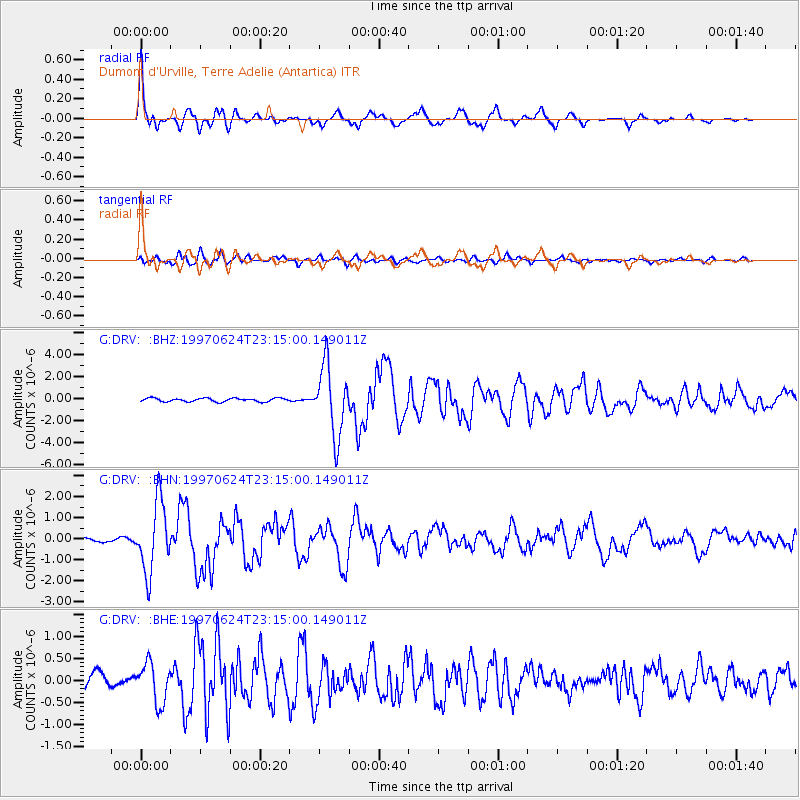
Signal To Noise
| Channel | StoN | STA | LTA |
| G:DRV: :BHN:19970624T23:15:00.149011Z | 10.468564 | 1.6516562E-6 | 1.5777294E-7 |
| G:DRV: :BHE:19970624T23:15:00.149011Z | 2.7118385 | 4.4948754E-7 | 1.6575011E-7 |
| G:DRV: :BHZ:19970624T23:15:00.149011Z | 20.337719 | 3.1569193E-6 | 1.5522484E-7 |
| Arrivals |
| Ps | 2.0 SECOND |
| PpPs | 8.1 SECOND |
| PsPs/PpSs | 10 SECOND |


