You are here: Home > Network List > TA - USArray Transportable Network (new EarthScope stations) Stations List
> Station W45A Hickory Valley, TN, USA > Earthquake Result Viewer
W45A Hickory Valley, TN, USA - Earthquake Result Viewer

| Earthquake location: |
Ecuador |
| Earthquake latitude/longitude: |
-1.8/-76.9 |
| Earthquake time(UTC): |
2011/08/15 (227) 02:53:18 GMT |
| Earthquake Depth: |
177 km |
| Earthquake Magnitude: |
5.7 MB, 5.7 MW, 5.7 MW |
| Earthquake Catalog/Contributor: |
WHDF/NEIC |
|
| Network: |
TA USArray Transportable Network (new EarthScope stations) |
| Station: |
W45A Hickory Valley, TN, USA |
| Lat/Lon: |
35.16 N/89.19 W |
| Elevation: |
187 m |
|
| Distance: |
38.5 deg |
| Az: |
343.758 deg |
| Baz: |
160.051 deg |
| Ray Param: |
0.074851036 |
| Estimated Moho Depth: |
10.5 km |
| Estimated Crust Vp/Vs: |
1.60 |
| Assumed Crust Vp: |
6.38 km/s |
| Estimated Crust Vs: |
3.988 km/s |
| Estimated Crust Poisson's Ratio: |
0.18 |
|
| Radial Match: |
84.24416 % |
| Radial Bump: |
395 |
| Transverse Match: |
65.055145 % |
| Transverse Bump: |
400 |
| SOD ConfigId: |
410809 |
| Insert Time: |
2012-01-06 05:57:37.176 +0000 |
| GWidth: |
2.5 |
| Max Bumps: |
400 |
| Tol: |
0.001 |
|
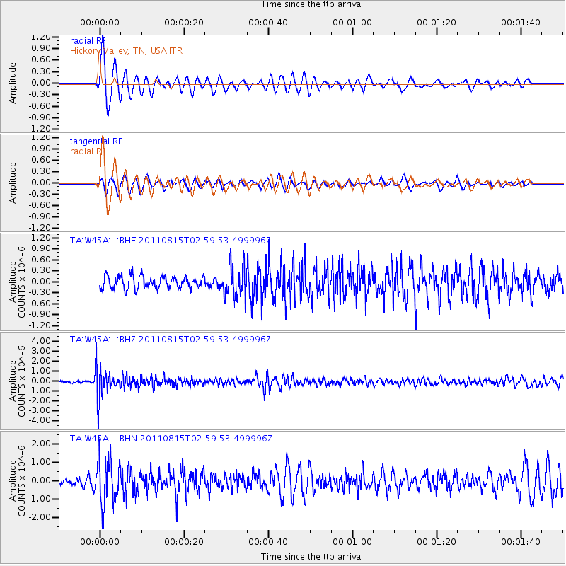
Signal To Noise
| Channel | StoN | STA | LTA |
| TA:W45A: :BHZ:20110815T02:59:53.499996Z | 19.945812 | 1.5067403E-6 | 7.5541685E-8 |
| TA:W45A: :BHN:20110815T02:59:53.499996Z | 5.4315267 | 1.2244935E-6 | 2.2544187E-7 |
| TA:W45A: :BHE:20110815T02:59:53.499996Z | 2.507663 | 4.1243206E-7 | 1.644687E-7 |
| Arrivals |
| Ps | 1.1 SECOND |
| PpPs | 4.0 SECOND |
| PsPs/PpSs | 5.0 SECOND |


