You are here: Home > Network List > TA - USArray Transportable Network (new EarthScope stations) Stations List
> Station L41A Preston, IA, USA > Earthquake Result Viewer
L41A Preston, IA, USA - Earthquake Result Viewer
| Earthquake location: |
Ecuador |
| Earthquake latitude/longitude: |
-1.8/-76.9 |
| Earthquake time(UTC): |
2011/08/15 (227) 02:53:18 GMT |
| Earthquake Depth: |
177 km |
| Earthquake Magnitude: |
5.7 MB, 5.7 MW, 5.7 MW |
| Earthquake Catalog/Contributor: |
WHDF/NEIC |
|
| Network: |
TA USArray Transportable Network (new EarthScope stations) |
| Station: |
L41A Preston, IA, USA |
| Lat/Lon: |
42.08 N/90.50 W |
| Elevation: |
238 m |
|
| Distance: |
45.4 deg |
| Az: |
345.775 deg |
| Baz: |
160.737 deg |
| Ray Param: |
0.0706516 |
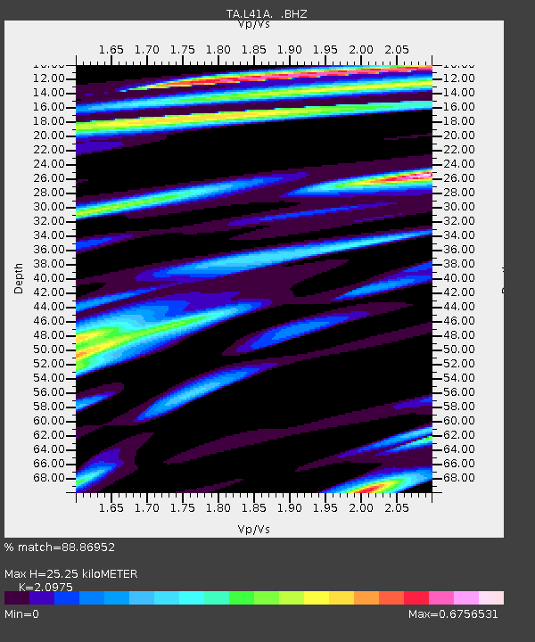
| Estimated Moho Depth: |
25.25 km |
| Estimated Crust Vp/Vs: |
2.10 |
| Assumed Crust Vp: |
6.53 km/s |
| Estimated Crust Vs: |
3.113 km/s |
| Estimated Crust Poisson's Ratio: |
0.35 |
|
| Radial Match: |
88.86952 % |
| Radial Bump: |
388 |
| Transverse Match: |
70.74313 % |
| Transverse Bump: |
400 |
| SOD ConfigId: |
410809 |
| Insert Time: |
2012-01-06 05:58:38.509 +0000 |
| GWidth: |
2.5 |
| Max Bumps: |
400 |
| Tol: |
0.001 |
|

Signal To Noise
| Channel | StoN | STA | LTA |
| TA:L41A: :BHZ:20110815T03:00:48.874996Z | 16.881968 | 1.9402496E-6 | 1.149303E-7 |
| TA:L41A: :BHN:20110815T03:00:48.874996Z | 16.774248 | 8.8614007E-7 | 5.282741E-8 |
| TA:L41A: :BHE:20110815T03:00:48.874996Z | 4.353648 | 3.575711E-7 | 8.213137E-8 |
| Arrivals |
| Ps | 4.5 SECOND |
| PpPs | 11 SECOND |
| PsPs/PpSs | 16 SECOND |


