You are here: Home > Network List > TA - USArray Transportable Network (new EarthScope stations) Stations List
> Station J39A Decorah, IA, USA > Earthquake Result Viewer
J39A Decorah, IA, USA - Earthquake Result Viewer
| Earthquake location: |
Ecuador |
| Earthquake latitude/longitude: |
-1.8/-76.9 |
| Earthquake time(UTC): |
2011/08/15 (227) 02:53:18 GMT |
| Earthquake Depth: |
177 km |
| Earthquake Magnitude: |
5.7 MB, 5.7 MW, 5.7 MW |
| Earthquake Catalog/Contributor: |
WHDF/NEIC |
|
| Network: |
TA USArray Transportable Network (new EarthScope stations) |
| Station: |
J39A Decorah, IA, USA |
| Lat/Lon: |
43.34 N/91.71 W |
| Elevation: |
350 m |
|
| Distance: |
46.9 deg |
| Az: |
345.206 deg |
| Baz: |
159.526 deg |
| Ray Param: |
0.06970269 |
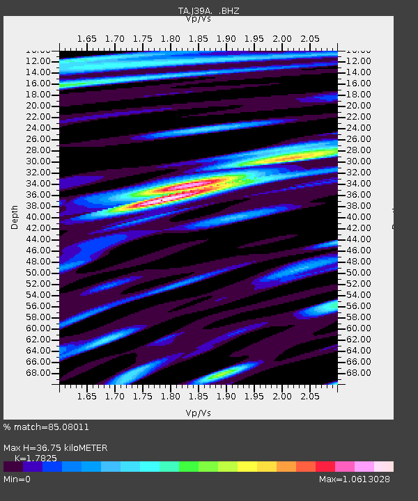
| Estimated Moho Depth: |
36.75 km |
| Estimated Crust Vp/Vs: |
1.78 |
| Assumed Crust Vp: |
6.53 km/s |
| Estimated Crust Vs: |
3.664 km/s |
| Estimated Crust Poisson's Ratio: |
0.27 |
|
| Radial Match: |
85.08011 % |
| Radial Bump: |
394 |
| Transverse Match: |
70.90699 % |
| Transverse Bump: |
400 |
| SOD ConfigId: |
410809 |
| Insert Time: |
2012-01-06 05:59:03.625 +0000 |
| GWidth: |
2.5 |
| Max Bumps: |
400 |
| Tol: |
0.001 |
|

Signal To Noise
| Channel | StoN | STA | LTA |
| TA:J39A: :BHZ:20110815T03:01:00.450009Z | 13.22259 | 9.023747E-7 | 6.824493E-8 |
| TA:J39A: :BHN:20110815T03:01:00.450009Z | 31.066319 | 1.0941199E-6 | 3.5218847E-8 |
| TA:J39A: :BHE:20110815T03:01:00.450009Z | 8.044687 | 3.8401313E-7 | 4.7734996E-8 |
| Arrivals |
| Ps | 4.7 SECOND |
| PpPs | 15 SECOND |
| PsPs/PpSs | 19 SECOND |


