You are here: Home > Network List > TA - USArray Transportable Network (new EarthScope stations) Stations List
> Station S41A Jillco Farms, Salem, MO, USA > Earthquake Result Viewer
S41A Jillco Farms, Salem, MO, USA - Earthquake Result Viewer
| Earthquake location: |
Ecuador |
| Earthquake latitude/longitude: |
-1.8/-76.9 |
| Earthquake time(UTC): |
2011/08/15 (227) 02:53:18 GMT |
| Earthquake Depth: |
177 km |
| Earthquake Magnitude: |
5.7 MB, 5.7 MW, 5.7 MW |
| Earthquake Catalog/Contributor: |
WHDF/NEIC |
|
| Network: |
TA USArray Transportable Network (new EarthScope stations) |
| Station: |
S41A Jillco Farms, Salem, MO, USA |
| Lat/Lon: |
37.59 N/91.75 W |
| Elevation: |
376 m |
|
| Distance: |
41.5 deg |
| Az: |
342.137 deg |
| Baz: |
157.298 deg |
| Ray Param: |
0.07305926 |
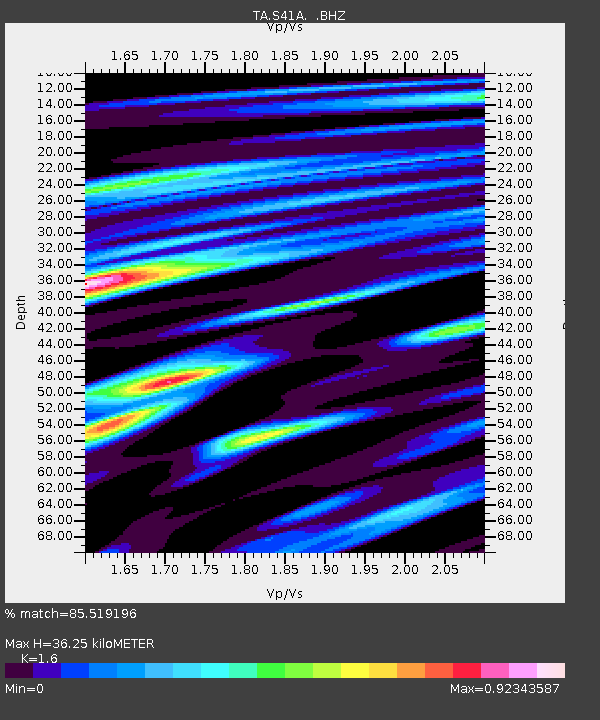
| Estimated Moho Depth: |
36.25 km |
| Estimated Crust Vp/Vs: |
1.60 |
| Assumed Crust Vp: |
6.53 km/s |
| Estimated Crust Vs: |
4.082 km/s |
| Estimated Crust Poisson's Ratio: |
0.18 |
|
| Radial Match: |
85.519196 % |
| Radial Bump: |
374 |
| Transverse Match: |
70.83064 % |
| Transverse Bump: |
400 |
| SOD ConfigId: |
410809 |
| Insert Time: |
2012-01-06 05:59:29.509 +0000 |
| GWidth: |
2.5 |
| Max Bumps: |
400 |
| Tol: |
0.001 |
|
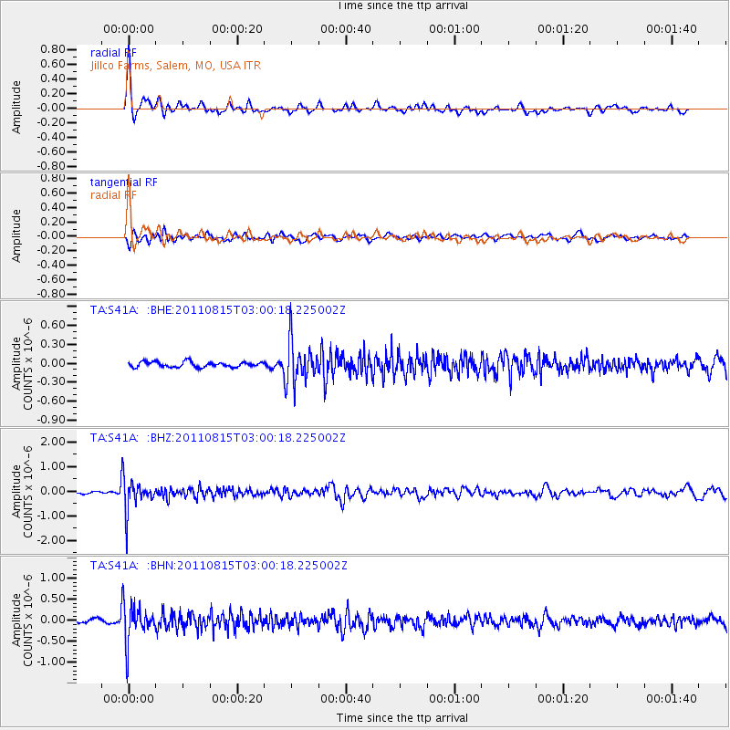
Signal To Noise
| Channel | StoN | STA | LTA |
| TA:S41A: :BHZ:20110815T03:00:18.225002Z | 9.998161 | 6.196978E-7 | 6.1981176E-8 |
| TA:S41A: :BHN:20110815T03:00:18.225002Z | 10.093225 | 4.2490598E-7 | 4.209814E-8 |
| TA:S41A: :BHE:20110815T03:00:18.225002Z | 7.8106365 | 3.220256E-7 | 4.122911E-8 |
| Arrivals |
| Ps | 3.6 SECOND |
| PpPs | 13 SECOND |
| PsPs/PpSs | 17 SECOND |


