You are here: Home > Network List > TA - USArray Transportable Network (new EarthScope stations) Stations List
> Station K41A Shullsburg, WI, USA > Earthquake Result Viewer
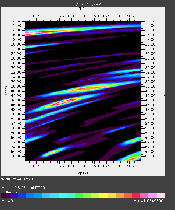
K41A Shullsburg, WI, USA - Earthquake Result Viewer
| Earthquake location: |
Ecuador |
| Earthquake latitude/longitude: |
-1.8/-76.9 |
| Earthquake time(UTC): |
2011/08/15 (227) 02:53:18 GMT |
| Earthquake Depth: |
177 km |
| Earthquake Magnitude: |
5.7 MB, 5.7 MW, 5.7 MW |
| Earthquake Catalog/Contributor: |
WHDF/NEIC |
|
| Network: |
TA USArray Transportable Network (new EarthScope stations) |
| Station: |
K41A Shullsburg, WI, USA |
| Lat/Lon: |
42.61 N/90.30 W |
| Elevation: |
298 m |
|
| Distance: |
45.8 deg |
| Az: |
346.207 deg |
| Baz: |
161.169 deg |
| Ray Param: |
0.070364416 |
| Estimated Moho Depth: |
15.25 km |
| Estimated Crust Vp/Vs: |
1.60 |
| Assumed Crust Vp: |
6.53 km/s |
| Estimated Crust Vs: |
4.082 km/s |
| Estimated Crust Poisson's Ratio: |
0.18 |
|
| Radial Match: |
83.54338 % |
| Radial Bump: |
400 |
| Transverse Match: |
72.43499 % |
| Transverse Bump: |
400 |
| SOD ConfigId: |
410809 |
| Insert Time: |
2012-01-06 05:59:42.899 +0000 |
| GWidth: |
2.5 |
| Max Bumps: |
400 |
| Tol: |
0.001 |
|

Signal To Noise
| Channel | StoN | STA | LTA |
| TA:K41A: :BHZ:20110815T03:00:52.450009Z | 13.349778 | 1.2673187E-6 | 9.493182E-8 |
| TA:K41A: :BHN:20110815T03:00:52.450009Z | 14.367957 | 6.6795377E-7 | 4.6489127E-8 |
| TA:K41A: :BHE:20110815T03:00:52.450009Z | 3.5847905 | 2.8288554E-7 | 7.891271E-8 |
| Arrivals |
| Ps | 1.5 SECOND |
| PpPs | 5.7 SECOND |
| PsPs/PpSs | 7.2 SECOND |


