You are here: Home > Network List > TA - USArray Transportable Network (new EarthScope stations) Stations List
> Station U41A Viola, AR, USA > Earthquake Result Viewer
U41A Viola, AR, USA - Earthquake Result Viewer
*The percent match for this event was below the threshold and hence no stack was calculated.
| Earthquake location: |
Ecuador |
| Earthquake latitude/longitude: |
-1.8/-76.9 |
| Earthquake time(UTC): |
2011/08/15 (227) 02:53:18 GMT |
| Earthquake Depth: |
177 km |
| Earthquake Magnitude: |
5.7 MB, 5.7 MW, 5.7 MW |
| Earthquake Catalog/Contributor: |
WHDF/NEIC |
|
| Network: |
TA USArray Transportable Network (new EarthScope stations) |
| Station: |
U41A Viola, AR, USA |
| Lat/Lon: |
36.34 N/91.92 W |
| Elevation: |
300 m |
|
| Distance: |
40.5 deg |
| Az: |
341.199 deg |
| Baz: |
156.486 deg |
| Ray Param: |
$rayparam |
*The percent match for this event was below the threshold and hence was not used in the summary stack. |
|
| Radial Match: |
78.10556 % |
| Radial Bump: |
400 |
| Transverse Match: |
59.847546 % |
| Transverse Bump: |
400 |
| SOD ConfigId: |
410809 |
| Insert Time: |
2012-01-06 06:00:02.124 +0000 |
| GWidth: |
2.5 |
| Max Bumps: |
400 |
| Tol: |
0.001 |
|
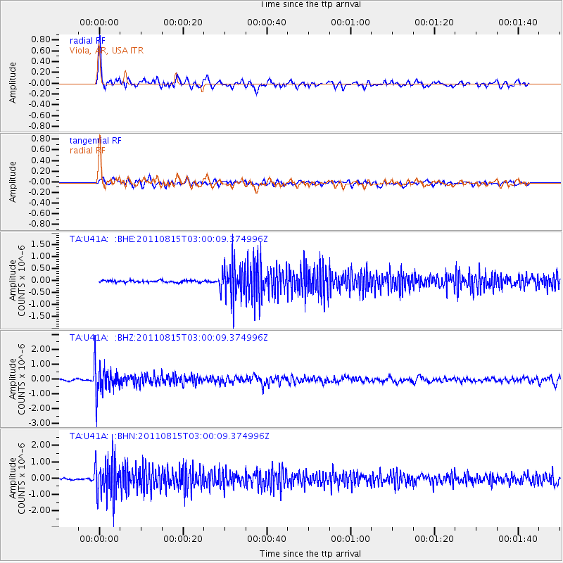
Signal To Noise
| Channel | StoN | STA | LTA |
| TA:U41A: :BHZ:20110815T03:00:09.374996Z | 12.313144 | 9.2188475E-7 | 7.486997E-8 |
| TA:U41A: :BHN:20110815T03:00:09.374996Z | 20.468395 | 1.1211392E-6 | 5.4774162E-8 |
| TA:U41A: :BHE:20110815T03:00:09.374996Z | 17.975382 | 6.8741747E-7 | 3.8242163E-8 |
| Arrivals |
| Ps | |
| PpPs | |
| PsPs/PpSs | |


