You are here: Home > Network List > TA - USArray Transportable Network (new EarthScope stations) Stations List
> Station M42A Sheffield, IL, USA > Earthquake Result Viewer
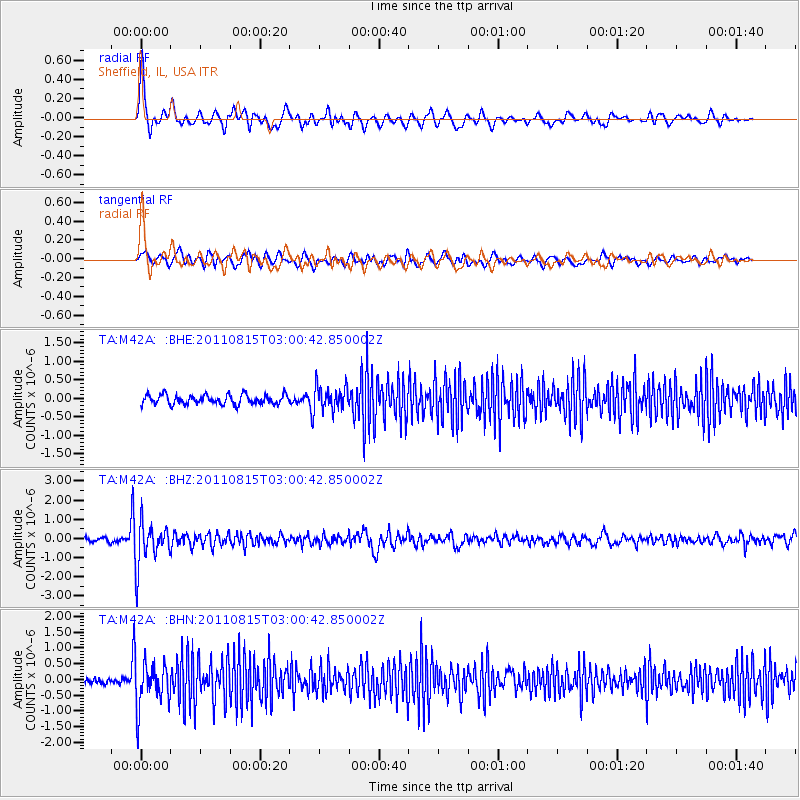
M42A Sheffield, IL, USA - Earthquake Result Viewer
*The percent match for this event was below the threshold and hence no stack was calculated.
| Earthquake location: |
Ecuador |
| Earthquake latitude/longitude: |
-1.8/-76.9 |
| Earthquake time(UTC): |
2011/08/15 (227) 02:53:18 GMT |
| Earthquake Depth: |
177 km |
| Earthquake Magnitude: |
5.7 MB, 5.7 MW, 5.7 MW |
| Earthquake Catalog/Contributor: |
WHDF/NEIC |
|
| Network: |
TA USArray Transportable Network (new EarthScope stations) |
| Station: |
M42A Sheffield, IL, USA |
| Lat/Lon: |
41.45 N/89.76 W |
| Elevation: |
212 m |
|
| Distance: |
44.6 deg |
| Az: |
346.232 deg |
| Baz: |
161.551 deg |
| Ray Param: |
$rayparam |
*The percent match for this event was below the threshold and hence was not used in the summary stack. |
|
| Radial Match: |
72.15556 % |
| Radial Bump: |
400 |
| Transverse Match: |
59.986237 % |
| Transverse Bump: |
400 |
| SOD ConfigId: |
410809 |
| Insert Time: |
2012-01-06 06:01:47.998 +0000 |
| GWidth: |
2.5 |
| Max Bumps: |
400 |
| Tol: |
0.001 |
|
Signal To Noise
| Channel | StoN | STA | LTA |
| TA:M42A: :BHZ:20110815T03:00:42.850002Z | 8.50177 | 1.1247589E-6 | 1.3229703E-7 |
| TA:M42A: :BHN:20110815T03:00:42.850002Z | 8.150579 | 7.0780044E-7 | 8.684051E-8 |
| TA:M42A: :BHE:20110815T03:00:42.850002Z | 2.5061872 | 3.1624245E-7 | 1.2618469E-7 |
| Arrivals |
| Ps | |
| PpPs | |
| PsPs/PpSs | |


