You are here: Home > Network List > G - GEOSCOPE Stations List
> Station DRV Dumont d'Urville, Terre Adelie (Antartica) > Earthquake Result Viewer
DRV Dumont d'Urville, Terre Adelie (Antartica) - Earthquake Result Viewer
| Earthquake location: |
South Of Fiji Islands |
| Earthquake latitude/longitude: |
-22.1/-176.8 |
| Earthquake time(UTC): |
1997/10/14 (287) 09:53:18 GMT |
| Earthquake Depth: |
167 km |
| Earthquake Magnitude: |
6.7 MB, 7.7 UNKNOWN, 7.4 ME |
| Earthquake Catalog/Contributor: |
WHDF/NEIC |
|
| Network: |
G GEOSCOPE |
| Station: |
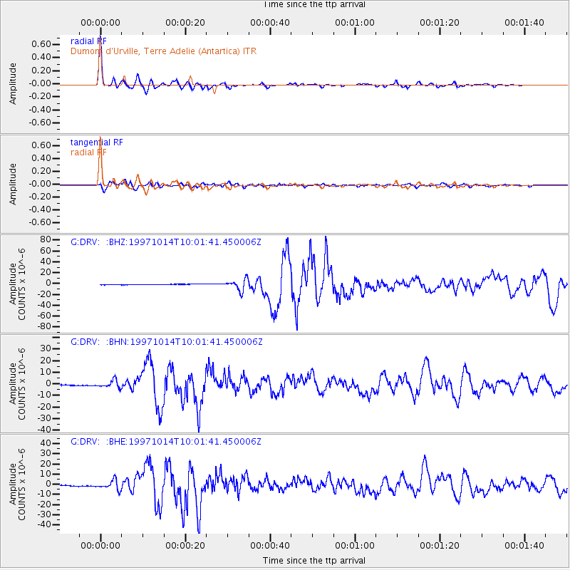
DRV Dumont d'Urville, Terre Adelie (Antartica) |
| Lat/Lon: |
66.67 S/140.01 E |
| Elevation: |
40 m |
|
| Distance: |
52.2 deg |
| Az: |
200.184 deg |
| Baz: |
53.443 deg |
| Ray Param: |
0.066309445 |
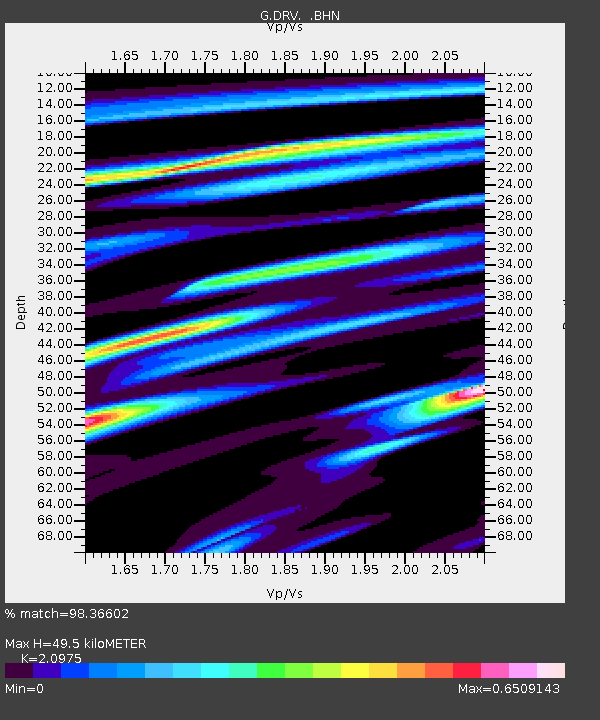
| Estimated Moho Depth: |
49.5 km |
| Estimated Crust Vp/Vs: |
2.10 |
| Assumed Crust Vp: |
6.39 km/s |
| Estimated Crust Vs: |
3.046 km/s |
| Estimated Crust Poisson's Ratio: |
0.35 |
|
| Radial Match: |
98.36602 % |
| Radial Bump: |
304 |
| Transverse Match: |
91.198845 % |
| Transverse Bump: |
400 |
| SOD ConfigId: |
6273 |
| Insert Time: |
2010-02-26 22:03:49.281 +0000 |
| GWidth: |
2.5 |
| Max Bumps: |
400 |
| Tol: |
0.001 |
|
Signal To Noise
| Channel | StoN | STA | LTA |
| G:DRV: :BHN:19971014T10:01:41.450006Z | 11.459037 | 3.202819E-6 | 2.7950156E-7 |
| G:DRV: :BHE:19971014T10:01:41.450006Z | 12.509909 | 4.674882E-6 | 3.7369432E-7 |
| G:DRV: :BHZ:19971014T10:01:41.450006Z | 18.393246 | 1.035934E-5 | 5.6321437E-7 |
| Arrivals |
| Ps | 8.9 SECOND |
| PpPs | 23 SECOND |
| PsPs/PpSs | 32 SECOND |


