You are here: Home > Network List > UW - Pacific Northwest Regional Seismic Network Stations List
> Station TAKO Tahkenitch, OR CREST BB SMO > Earthquake Result Viewer
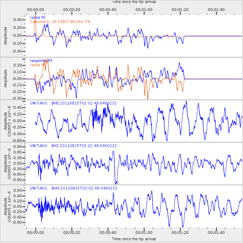
TAKO Tahkenitch, OR CREST BB SMO - Earthquake Result Viewer
*The percent match for this event was below the threshold and hence no stack was calculated.
| Earthquake location: |
Ecuador |
| Earthquake latitude/longitude: |
-1.8/-76.9 |
| Earthquake time(UTC): |
2011/08/15 (227) 02:53:18 GMT |
| Earthquake Depth: |
177 km |
| Earthquake Magnitude: |
5.7 MB, 5.7 MW, 5.7 MW |
| Earthquake Catalog/Contributor: |
WHDF/NEIC |
|
| Network: |
UW Pacific Northwest Regional Seismic Network |
| Station: |
TAKO Tahkenitch, OR CREST BB SMO |
| Lat/Lon: |
43.74 N/124.08 W |
| Elevation: |
46 m |
|
| Distance: |
61.9 deg |
| Az: |
322.951 deg |
| Baz: |
123.809 deg |
| Ray Param: |
$rayparam |
*The percent match for this event was below the threshold and hence was not used in the summary stack. |
|
| Radial Match: |
58.422318 % |
| Radial Bump: |
400 |
| Transverse Match: |
48.82635 % |
| Transverse Bump: |
400 |
| SOD ConfigId: |
410809 |
| Insert Time: |
2012-01-06 06:05:08.276 +0000 |
| GWidth: |
2.5 |
| Max Bumps: |
400 |
| Tol: |
0.001 |
|
Signal To Noise
| Channel | StoN | STA | LTA |
| UW:TAKO: :BHZ:20110815T03:02:48.646023Z | 1.4663523 | 2.7502972E-7 | 1.8756046E-7 |
| UW:TAKO: :BHN:20110815T03:02:48.646023Z | 0.7731425 | 1.6024502E-7 | 2.0726452E-7 |
| UW:TAKO: :BHE:20110815T03:02:48.646023Z | 1.3201617 | 2.7030376E-7 | 2.0475049E-7 |
| Arrivals |
| Ps | |
| PpPs | |
| PsPs/PpSs | |


