You are here: Home > Network List > UW - Pacific Northwest Regional Seismic Network Stations List
> Station MRBL Marblemount, WA, USA > Earthquake Result Viewer
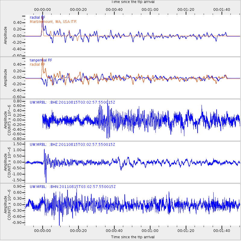
MRBL Marblemount, WA, USA - Earthquake Result Viewer
*The percent match for this event was below the threshold and hence no stack was calculated.
| Earthquake location: |
Ecuador |
| Earthquake latitude/longitude: |
-1.8/-76.9 |
| Earthquake time(UTC): |
2011/08/15 (227) 02:53:18 GMT |
| Earthquake Depth: |
177 km |
| Earthquake Magnitude: |
5.7 MB, 5.7 MW, 5.7 MW |
| Earthquake Catalog/Contributor: |
WHDF/NEIC |
|
| Network: |
UW Pacific Northwest Regional Seismic Network |
| Station: |
MRBL Marblemount, WA, USA |
| Lat/Lon: |
48.52 N/121.48 W |
| Elevation: |
75 m |
|
| Distance: |
63.3 deg |
| Az: |
328.499 deg |
| Baz: |
128.234 deg |
| Ray Param: |
$rayparam |
*The percent match for this event was below the threshold and hence was not used in the summary stack. |
|
| Radial Match: |
67.77082 % |
| Radial Bump: |
400 |
| Transverse Match: |
57.59041 % |
| Transverse Bump: |
400 |
| SOD ConfigId: |
410809 |
| Insert Time: |
2012-01-06 06:05:28.190 +0000 |
| GWidth: |
2.5 |
| Max Bumps: |
400 |
| Tol: |
0.001 |
|
Signal To Noise
| Channel | StoN | STA | LTA |
| UW:MRBL: :BHZ:20110815T03:02:57.550015Z | 6.958846 | 4.72677E-7 | 6.7924624E-8 |
| UW:MRBL: :BHN:20110815T03:02:57.550015Z | 1.798484 | 2.196216E-7 | 1.2211484E-7 |
| UW:MRBL: :BHE:20110815T03:02:57.550015Z | 2.1150491 | 2.5346137E-7 | 1.1983711E-7 |
| Arrivals |
| Ps | |
| PpPs | |
| PsPs/PpSs | |


