You are here: Home > Network List > G - GEOSCOPE Stations List
> Station INU Inuyama, Japan > Earthquake Result Viewer
INU Inuyama, Japan - Earthquake Result Viewer
| Earthquake location: |
Ceram Sea |
| Earthquake latitude/longitude: |
-2.3/128.0 |
| Earthquake time(UTC): |
2011/08/16 (228) 11:03:57 GMT |
| Earthquake Depth: |
35 km |
| Earthquake Magnitude: |
6.1 MB, 5.7 MS, 6.0 MW, 5.9 MW |
| Earthquake Catalog/Contributor: |
WHDF/NEIC |
|
| Network: |
G GEOSCOPE |
| Station: |
INU Inuyama, Japan |
| Lat/Lon: |
35.35 N/137.03 E |
| Elevation: |
132 m |
|
| Distance: |
38.4 deg |
| Az: |
11.91 deg |
| Baz: |
194.61 deg |
| Ray Param: |
0.07549879 |
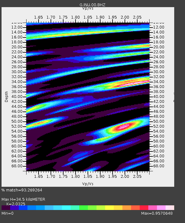
| Estimated Moho Depth: |
34.5 km |
| Estimated Crust Vp/Vs: |
2.03 |
| Assumed Crust Vp: |
6.461 km/s |
| Estimated Crust Vs: |
3.179 km/s |
| Estimated Crust Poisson's Ratio: |
0.34 |
|
| Radial Match: |
93.269264 % |
| Radial Bump: |
400 |
| Transverse Match: |
86.59893 % |
| Transverse Bump: |
400 |
| SOD ConfigId: |
410809 |
| Insert Time: |
2012-01-06 06:12:49.471 +0000 |
| GWidth: |
2.5 |
| Max Bumps: |
400 |
| Tol: |
0.001 |
|

Signal To Noise
| Channel | StoN | STA | LTA |
| G:INU:00:BHZ:20110816T11:10:45.560992Z | 8.981065 | 7.2426474E-7 | 8.064353E-8 |
| G:INU:00:BHN:20110816T11:10:45.560992Z | 3.9872668 | 4.2083437E-7 | 1.0554457E-7 |
| G:INU:00:BHE:20110816T11:10:45.560992Z | 3.1002498 | 2.3152717E-7 | 7.4680166E-8 |
| Arrivals |
| Ps | 5.9 SECOND |
| PpPs | 15 SECOND |
| PsPs/PpSs | 21 SECOND |


