You are here: Home > Network List > TA - USArray Transportable Network (new EarthScope stations) Stations List
> Station L02D Cave Junction, OR, USA > Earthquake Result Viewer
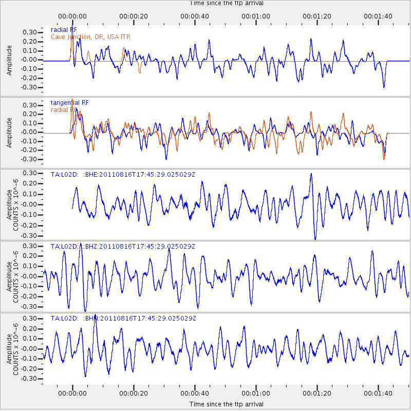
L02D Cave Junction, OR, USA - Earthquake Result Viewer
*The percent match for this event was below the threshold and hence no stack was calculated.
| Earthquake location: |
Eastern New Guinea Reg., P.N.G. |
| Earthquake latitude/longitude: |
-5.6/147.1 |
| Earthquake time(UTC): |
2011/08/16 (228) 17:33:07 GMT |
| Earthquake Depth: |
186 km |
| Earthquake Magnitude: |
5.6 MW, 5.2 MB, 5.6 MW |
| Earthquake Catalog/Contributor: |
WHDF/NEIC |
|
| Network: |
TA USArray Transportable Network (new EarthScope stations) |
| Station: |
L02D Cave Junction, OR, USA |
| Lat/Lon: |
42.16 N/123.60 W |
| Elevation: |
458 m |
|
| Distance: |
93.1 deg |
| Az: |
48.124 deg |
| Baz: |
265.393 deg |
| Ray Param: |
$rayparam |
*The percent match for this event was below the threshold and hence was not used in the summary stack. |
|
| Radial Match: |
57.594425 % |
| Radial Bump: |
400 |
| Transverse Match: |
53.937626 % |
| Transverse Bump: |
400 |
| SOD ConfigId: |
410809 |
| Insert Time: |
2012-01-06 06:20:48.752 +0000 |
| GWidth: |
2.5 |
| Max Bumps: |
400 |
| Tol: |
0.001 |
|
Signal To Noise
| Channel | StoN | STA | LTA |
| TA:L02D: :BHZ:20110816T17:45:29.025029Z | 2.364989 | 2.0073261E-7 | 8.487676E-8 |
| TA:L02D: :BHN:20110816T17:45:29.025029Z | 1.496048 | 1.3425016E-7 | 8.973653E-8 |
| TA:L02D: :BHE:20110816T17:45:29.025029Z | 0.57670385 | 4.7779793E-8 | 8.284979E-8 |
| Arrivals |
| Ps | |
| PpPs | |
| PsPs/PpSs | |


