You are here: Home > Network List > UW - Pacific Northwest Regional Seismic Network Stations List
> Station HOOD Mt Hood Meadows, OR CREST BB SMO > Earthquake Result Viewer
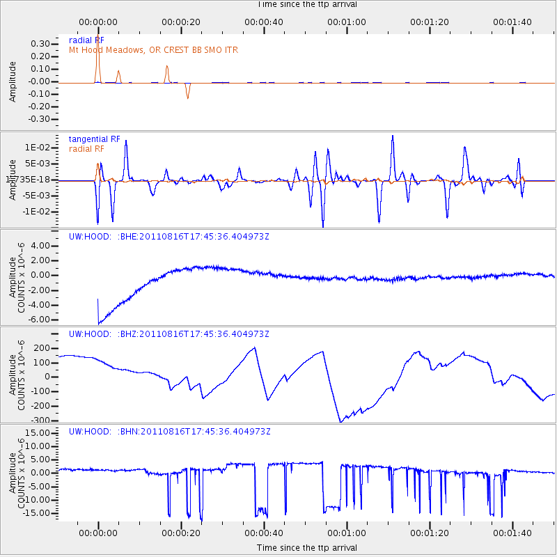
HOOD Mt Hood Meadows, OR CREST BB SMO - Earthquake Result Viewer
*The percent match for this event was below the threshold and hence no stack was calculated.
| Earthquake location: |
Eastern New Guinea Reg., P.N.G. |
| Earthquake latitude/longitude: |
-5.6/147.1 |
| Earthquake time(UTC): |
2011/08/16 (228) 17:33:07 GMT |
| Earthquake Depth: |
186 km |
| Earthquake Magnitude: |
5.6 MW, 5.2 MB, 5.6 MW |
| Earthquake Catalog/Contributor: |
WHDF/NEIC |
|
| Network: |
UW Pacific Northwest Regional Seismic Network |
| Station: |
HOOD Mt Hood Meadows, OR CREST BB SMO |
| Lat/Lon: |
45.32 N/121.65 W |
| Elevation: |
1520 m |
|
| Distance: |
94.8 deg |
| Az: |
45.056 deg |
| Baz: |
266.948 deg |
| Ray Param: |
$rayparam |
*The percent match for this event was below the threshold and hence was not used in the summary stack. |
|
| Radial Match: |
71.05029 % |
| Radial Bump: |
227 |
| Transverse Match: |
77.004814 % |
| Transverse Bump: |
400 |
| SOD ConfigId: |
410809 |
| Insert Time: |
2012-01-06 06:21:29.813 +0000 |
| GWidth: |
2.5 |
| Max Bumps: |
400 |
| Tol: |
0.001 |
|
Signal To Noise
| Channel | StoN | STA | LTA |
| UW:HOOD: :BHZ:20110816T17:45:36.404973Z | 0.8184656 | 3.440412E-4 | 4.2034904E-4 |
| UW:HOOD: :BHN:20110816T17:45:36.404973Z | 0.6624476 | 4.272355E-6 | 6.4493483E-6 |
| UW:HOOD: :BHE:20110816T17:45:36.404973Z | 1.0410835 | 2.4619803E-6 | 2.364825E-6 |
| Arrivals |
| Ps | |
| PpPs | |
| PsPs/PpSs | |


