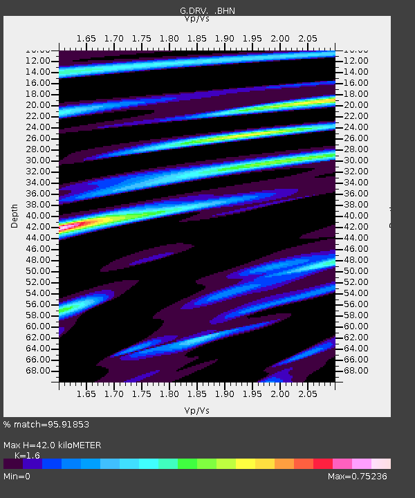
DRV Dumont d'Urville, Terre Adelie (Antartica) - Earthquake Result Viewer
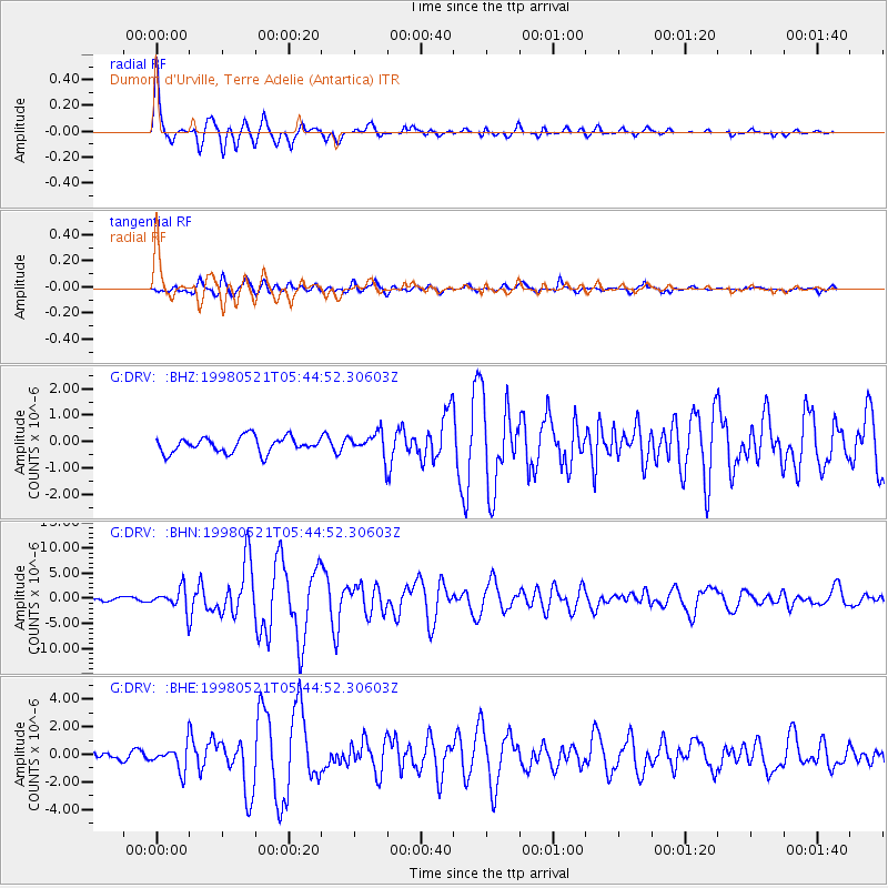
Earthquake location: Minahassa Peninsula, Sulawesi
Earthquake latitude/longitude: 0.2/119.6
Earthquake time(UTC): 1998/05/21 (141) 05:34:25 GMT
Earthquake Depth: 33 km
Earthquake Magnitude: 6.2 MB, 6.3 MS, 6.6 UNKNOWN, 6.6 MW
Earthquake Catalog/Contributor: WHDF/NEIC
Network: G GEOSCOPE
Station: DRV Dumont d'Urville, Terre Adelie (Antartica)
Lat/Lon: 66.67 S/140.01 E
Elevation: 40 m
Distance: 68.3 deg
Az: 171.394 deg
Baz: 337.935 deg
Ray Param: 0.056354012
Estimated Moho Depth: 42.0 km
Estimated Crust Vp/Vs: 1.60
Assumed Crust Vp: 6.39 km/s
Estimated Crust Vs: 3.994 km/s
Estimated Crust Poisson's Ratio: 0.18
Radial Match: 95.91853 %
Radial Bump: 400
Transverse Match: 83.02552 %
Transverse Bump: 400
SOD ConfigId: 4480
Insert Time: 2010-02-26 22:04:03.122 +0000
GWidth: 2.5
Max Bumps: 400
Tol: 0.001

Signal To Noise

ChannelStoNSTALTA
G:DRV: :BHN:19980521T05:44:52.30603Z7.05765062.2009388E-63.118515E-7
G:DRV: :BHE:19980521T05:44:52.30603Z2.2893248.9763705E-73.9209695E-7
G:DRV: :BHZ:19980521T05:44:52.30603Z1.42761644.2298217E-72.962856E-7
Arrivals
Ps4.1 SECOND
PpPs16 SECOND
PsPs/PpSs20 SECOND