You are here: Home > Network List > AR - Northern Arizona Network Stations List
> Station X18A Snowflake, AZ, USA > Earthquake Result Viewer
X18A Snowflake, AZ, USA - Earthquake Result Viewer
| Earthquake location: |
Off East Coast Of Honshu, Japan |
| Earthquake latitude/longitude: |
36.8/143.8 |
| Earthquake time(UTC): |
2011/08/17 (229) 11:44:08 GMT |
| Earthquake Depth: |
9.0 km |
| Earthquake Magnitude: |
6.1 MB, 5.8 MS, 6.2 MW, 6.1 MW |
| Earthquake Catalog/Contributor: |
WHDF/NEIC |
|
| Network: |
AR Northern Arizona Network |
| Station: |
X18A Snowflake, AZ, USA |
| Lat/Lon: |
34.53 N/109.95 W |
| Elevation: |
1751 m |
|
| Distance: |
81.3 deg |
| Az: |
53.285 deg |
| Baz: |
308.768 deg |
| Ray Param: |
0.04765079 |
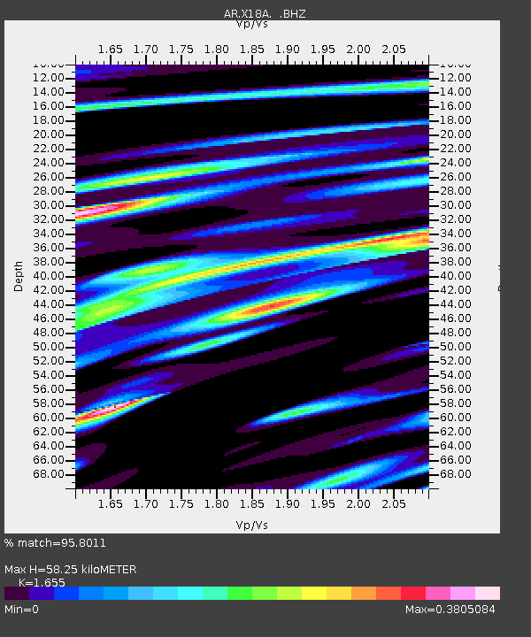
| Estimated Moho Depth: |
58.25 km |
| Estimated Crust Vp/Vs: |
1.65 |
| Assumed Crust Vp: |
6.496 km/s |
| Estimated Crust Vs: |
3.925 km/s |
| Estimated Crust Poisson's Ratio: |
0.21 |
|
| Radial Match: |
95.8011 % |
| Radial Bump: |
400 |
| Transverse Match: |
80.4958 % |
| Transverse Bump: |
400 |
| SOD ConfigId: |
410809 |
| Insert Time: |
2012-01-06 06:24:49.499 +0000 |
| GWidth: |
2.5 |
| Max Bumps: |
400 |
| Tol: |
0.001 |
|

Signal To Noise
| Channel | StoN | STA | LTA |
| AR:X18A: :BHZ:20110817T11:55:53.750005Z | 12.164835 | 1.1043757E-6 | 9.078427E-8 |
| AR:X18A: :BHN:20110817T11:55:53.750005Z | 4.8127007 | 3.4337785E-7 | 7.134827E-8 |
| AR:X18A: :BHE:20110817T11:55:53.750005Z | 6.5039787 | 2.8621415E-7 | 4.400601E-8 |
| Arrivals |
| Ps | 6.1 SECOND |
| PpPs | 23 SECOND |
| PsPs/PpSs | 29 SECOND |


