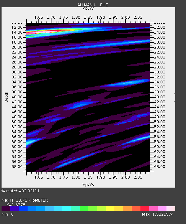
MANU Manus Island, Papau New Guinea - Earthquake Result Viewer

Earthquake location: Off East Coast Of Honshu, Japan
Earthquake latitude/longitude: 36.8/143.8
Earthquake time(UTC): 2011/08/17 (229) 11:44:08 GMT
Earthquake Depth: 9.0 km
Earthquake Magnitude: 6.1 MB, 5.8 MS, 6.2 MW, 6.1 MW
Earthquake Catalog/Contributor: WHDF/NEIC
Network: AU Australian Seismological Centre
Station: MANU Manus Island, Papau New Guinea
Lat/Lon: 2.04 S/147.37 E
Elevation: 142 m
Distance: 38.8 deg
Az: 174.253 deg
Baz: 355.385 deg
Ray Param: 0.07538128
Estimated Moho Depth: 13.75 km
Estimated Crust Vp/Vs: 1.68
Assumed Crust Vp: 4.082 km/s
Estimated Crust Vs: 2.434 km/s
Estimated Crust Poisson's Ratio: 0.22
Radial Match: 83.92111 %
Radial Bump: 263
Transverse Match: 60.726444 %
Transverse Bump: 336
SOD ConfigId: 410809
Insert Time: 2012-01-06 06:26:11.755 +0000
GWidth: 2.5
Max Bumps: 400
Tol: 0.001

Signal To Noise

ChannelStoNSTALTA
AU:MANU: :BHZ:20110817T11:51:02.120Z3.47616368.7147896E-72.5070136E-7
AU:MANU: :BHN:20110817T11:51:02.120Z2.56263885.1129024E-71.9951709E-7
AU:MANU: :BHE:20110817T11:51:02.120Z0.849991261.811585E-72.1312984E-7
Arrivals
Ps2.3 SECOND
PpPs8.8 SECOND
PsPs/PpSs11 SECOND