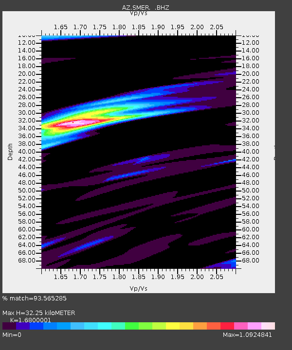
SMER AZ.SMER - Earthquake Result Viewer
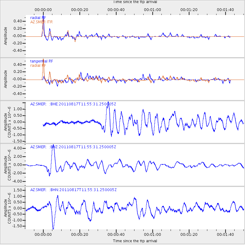
Earthquake location: Off East Coast Of Honshu, Japan
Earthquake latitude/longitude: 36.8/143.8
Earthquake time(UTC): 2011/08/17 (229) 11:44:08 GMT
Earthquake Depth: 9.0 km
Earthquake Magnitude: 6.1 MB, 5.8 MS, 6.2 MW, 6.1 MW
Earthquake Catalog/Contributor: WHDF/NEIC
Network: AZ ANZA Regional Network
Station: SMER AZ.SMER
Lat/Lon: 33.46 N/117.17 W
Elevation: 355 m
Distance: 77.2 deg
Az: 57.839 deg
Baz: 305.593 deg
Ray Param: 0.050476722
Estimated Moho Depth: 32.25 km
Estimated Crust Vp/Vs: 1.68
Assumed Crust Vp: 6.264 km/s
Estimated Crust Vs: 3.728 km/s
Estimated Crust Poisson's Ratio: 0.23
Radial Match: 93.565285 %
Radial Bump: 400
Transverse Match: 65.657 %
Transverse Bump: 400
SOD ConfigId: 410809
Insert Time: 2012-01-06 06:27:33.565 +0000
GWidth: 2.5
Max Bumps: 400
Tol: 0.001

Signal To Noise

ChannelStoNSTALTA
AZ:SMER: :BHZ:20110817T11:55:31.250005Z12.5806351.2653122E-61.0057618E-7
AZ:SMER: :BHN:20110817T11:55:31.250005Z1.57991543.2216042E-72.039099E-7
AZ:SMER: :BHE:20110817T11:55:31.250005Z4.424733.747278E-78.468941E-8
Arrivals
Ps3.6 SECOND
PpPs13 SECOND
PsPs/PpSs17 SECOND