You are here: Home > Network List > CI - Caltech Regional Seismic Network Stations List
> Station CWC Cottonwood Creek, Lone Pine, CA, USA > Earthquake Result Viewer
CWC Cottonwood Creek, Lone Pine, CA, USA - Earthquake Result Viewer
| Earthquake location: |
Off East Coast Of Honshu, Japan |
| Earthquake latitude/longitude: |
36.8/143.8 |
| Earthquake time(UTC): |
2011/08/17 (229) 11:44:08 GMT |
| Earthquake Depth: |
9.0 km |
| Earthquake Magnitude: |
6.1 MB, 5.8 MS, 6.2 MW, 6.1 MW |
| Earthquake Catalog/Contributor: |
WHDF/NEIC |
|
| Network: |
CI Caltech Regional Seismic Network |
| Station: |
CWC Cottonwood Creek, Lone Pine, CA, USA |
| Lat/Lon: |
36.44 N/118.08 W |
| Elevation: |
1595 m |
|
| Distance: |
74.9 deg |
| Az: |
55.773 deg |
| Baz: |
304.576 deg |
| Ray Param: |
0.05203055 |
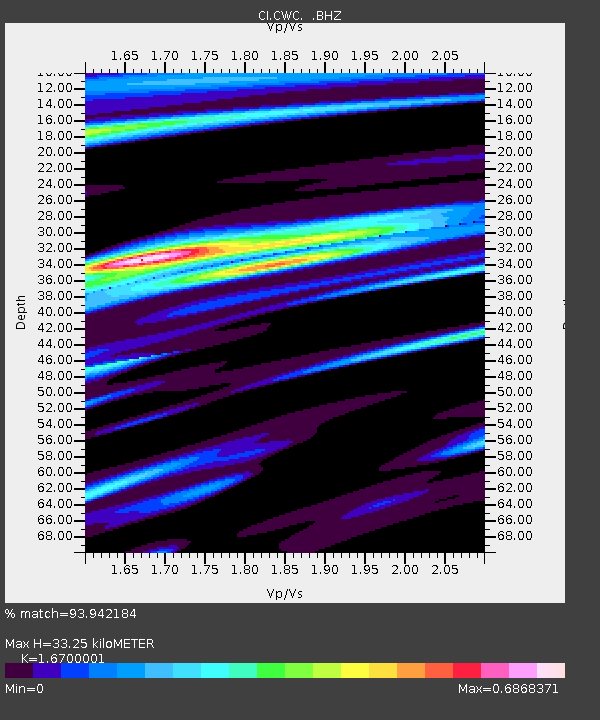
| Estimated Moho Depth: |
33.25 km |
| Estimated Crust Vp/Vs: |
1.67 |
| Assumed Crust Vp: |
6.291 km/s |
| Estimated Crust Vs: |
3.767 km/s |
| Estimated Crust Poisson's Ratio: |
0.22 |
|
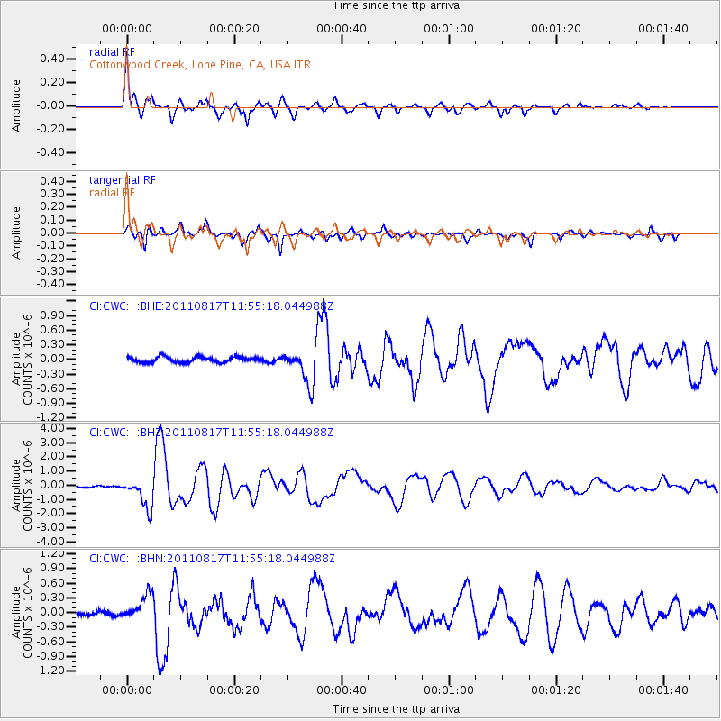
| Radial Match: |
93.942184 % |
| Radial Bump: |
391 |
| Transverse Match: |
86.687325 % |
| Transverse Bump: |
400 |
| SOD ConfigId: |
410809 |
| Insert Time: |
2012-01-06 06:29:26.454 +0000 |
| GWidth: |
2.5 |
| Max Bumps: |
400 |
| Tol: |
0.001 |
|
Signal To Noise
| Channel | StoN | STA | LTA |
| CI:CWC: :BHZ:20110817T11:55:18.044988Z | 15.0915365 | 1.064303E-6 | 7.0523164E-8 |
| CI:CWC: :BHN:20110817T11:55:18.044988Z | 4.0731764 | 2.5697224E-7 | 6.308891E-8 |
| CI:CWC: :BHE:20110817T11:55:18.044988Z | 6.694662 | 3.6410404E-7 | 5.438722E-8 |
| Arrivals |
| Ps | 3.7 SECOND |
| PpPs | 14 SECOND |
| PsPs/PpSs | 17 SECOND |


