You are here: Home > Network List > G - GEOSCOPE Stations List
> Station DRV Dumont d'Urville, Terre Adelie (Antartica) > Earthquake Result Viewer
DRV Dumont d'Urville, Terre Adelie (Antartica) - Earthquake Result Viewer
| Earthquake location: |
Santa Cruz Islands |
| Earthquake latitude/longitude: |
-11.0/166.2 |
| Earthquake time(UTC): |
1998/07/16 (197) 11:56:36 GMT |
| Earthquake Depth: |
110 km |
| Earthquake Magnitude: |
6.4 MB, 6.7 MS, 7.1 UNKNOWN, 6.9 ME |
| Earthquake Catalog/Contributor: |
WHDF/NEIC |
|
| Network: |
G GEOSCOPE |
| Station: |
DRV Dumont d'Urville, Terre Adelie (Antartica) |
| Lat/Lon: |
66.67 S/140.01 E |
| Elevation: |
40 m |
|
| Distance: |
58.3 deg |
| Az: |
191.909 deg |
| Baz: |
30.569 deg |
| Ray Param: |
0.06261238 |
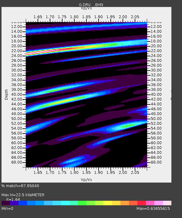
| Estimated Moho Depth: |
22.5 km |
| Estimated Crust Vp/Vs: |
1.64 |
| Assumed Crust Vp: |
6.39 km/s |
| Estimated Crust Vs: |
3.896 km/s |
| Estimated Crust Poisson's Ratio: |
0.20 |
|
| Radial Match: |
97.95848 % |
| Radial Bump: |
254 |
| Transverse Match: |
90.131454 % |
| Transverse Bump: |
400 |
| SOD ConfigId: |
4480 |
| Insert Time: |
2010-02-26 22:04:21.080 +0000 |
| GWidth: |
2.5 |
| Max Bumps: |
400 |
| Tol: |
0.001 |
|
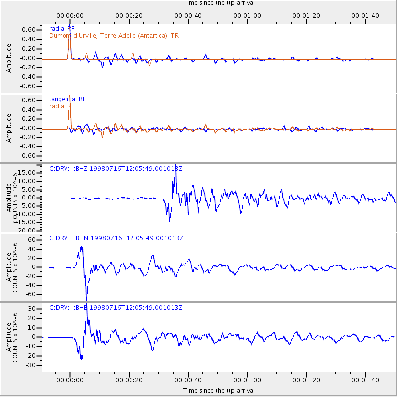
Signal To Noise
| Channel | StoN | STA | LTA |
| G:DRV: :BHN:19980716T12:05:49.001013Z | 66.94644 | 2.1483847E-5 | 3.20911E-7 |
| G:DRV: :BHE:19980716T12:05:49.001013Z | 26.560297 | 1.03540315E-5 | 3.8983117E-7 |
| G:DRV: :BHZ:19980716T12:05:49.001013Z | 14.294123 | 5.59993E-6 | 3.9176447E-7 |
| Arrivals |
| Ps | 2.4 SECOND |
| PpPs | 8.8 SECOND |
| PsPs/PpSs | 11 SECOND |


