You are here: Home > Network List > CI - Caltech Regional Seismic Network Stations List
> Station DEC Green Verdugo Microwave Site, Sunland, CA, USA > Earthquake Result Viewer
DEC Green Verdugo Microwave Site, Sunland, CA, USA - Earthquake Result Viewer

| Earthquake location: |
Off East Coast Of Honshu, Japan |
| Earthquake latitude/longitude: |
36.8/143.8 |
| Earthquake time(UTC): |
2011/08/17 (229) 11:44:08 GMT |
| Earthquake Depth: |
9.0 km |
| Earthquake Magnitude: |
6.1 MB, 5.8 MS, 6.2 MW, 6.1 MW |
| Earthquake Catalog/Contributor: |
WHDF/NEIC |
|
| Network: |
CI Caltech Regional Seismic Network |
| Station: |
DEC Green Verdugo Microwave Site, Sunland, CA, USA |
| Lat/Lon: |
34.25 N/118.33 W |
| Elevation: |
519 m |
|
| Distance: |
76.0 deg |
| Az: |
57.747 deg |
| Baz: |
304.927 deg |
| Ray Param: |
0.051315073 |
| Estimated Moho Depth: |
13.0 km |
| Estimated Crust Vp/Vs: |
2.02 |
| Assumed Crust Vp: |
6.1 km/s |
| Estimated Crust Vs: |
3.02 km/s |
| Estimated Crust Poisson's Ratio: |
0.34 |
|
| Radial Match: |
89.97459 % |
| Radial Bump: |
400 |
| Transverse Match: |
84.11357 % |
| Transverse Bump: |
400 |
| SOD ConfigId: |
410809 |
| Insert Time: |
2012-01-06 06:31:58.105 +0000 |
| GWidth: |
2.5 |
| Max Bumps: |
400 |
| Tol: |
0.001 |
|
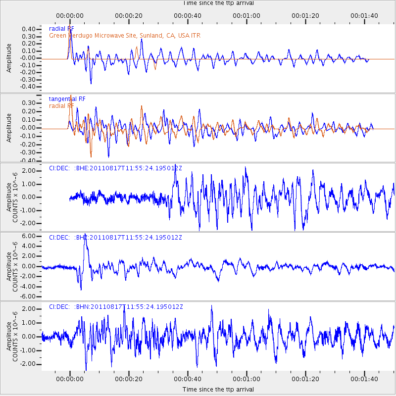
Signal To Noise
| Channel | StoN | STA | LTA |
| CI:DEC: :BHZ:20110817T11:55:24.195012Z | 9.355534 | 1.5586014E-6 | 1.6659675E-7 |
| CI:DEC: :BHN:20110817T11:55:24.195012Z | 2.2665186 | 5.880225E-7 | 2.5943865E-7 |
| CI:DEC: :BHE:20110817T11:55:24.195012Z | 2.1172502 | 4.830362E-7 | 2.281432E-7 |
| Arrivals |
| Ps | 2.2 SECOND |
| PpPs | 6.3 SECOND |
| PsPs/PpSs | 8.5 SECOND |


