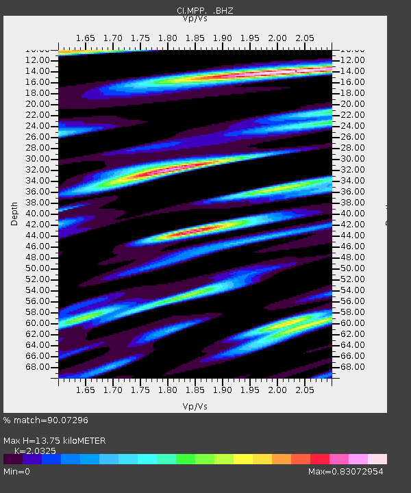
MPP McPhearson Peak - Earthquake Result Viewer
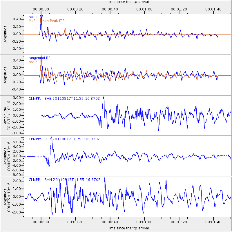
Earthquake location: Off East Coast Of Honshu, Japan
Earthquake latitude/longitude: 36.8/143.8
Earthquake time(UTC): 2011/08/17 (229) 11:44:08 GMT
Earthquake Depth: 9.0 km
Earthquake Magnitude: 6.1 MB, 5.8 MS, 6.2 MW, 6.1 MW
Earthquake Catalog/Contributor: WHDF/NEIC
Network: CI Caltech Regional Seismic Network
Station: MPP McPhearson Peak
Lat/Lon: 34.89 N/119.81 W
Elevation: 1739 m
Distance: 74.6 deg
Az: 57.923 deg
Baz: 304.136 deg
Ray Param: 0.052226752
Estimated Moho Depth: 13.75 km
Estimated Crust Vp/Vs: 2.03
Assumed Crust Vp: 6.1 km/s
Estimated Crust Vs: 3.001 km/s
Estimated Crust Poisson's Ratio: 0.34
Radial Match: 90.07296 %
Radial Bump: 400
Transverse Match: 81.41615 %
Transverse Bump: 400
SOD ConfigId: 410809
Insert Time: 2012-01-06 06:32:11.994 +0000
GWidth: 2.5
Max Bumps: 400
Tol: 0.001

Signal To Noise

ChannelStoNSTALTA
CI:MPP: :BHZ:20110817T11:55:16.370Z12.3104191.541813E-61.2524455E-7
CI:MPP: :BHN:20110817T11:55:16.370Z1.48613853.4622693E-72.3297085E-7
CI:MPP: :BHE:20110817T11:55:16.370Z2.42987325.826469E-72.397849E-7
Arrivals
Ps2.4 SECOND
PpPs6.7 SECOND
PsPs/PpSs9.0 SECOND