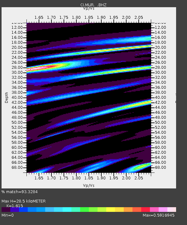
MUR Murrieta - Earthquake Result Viewer
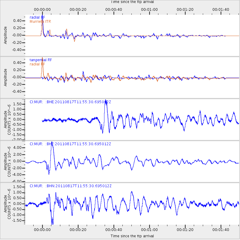
Earthquake location: Off East Coast Of Honshu, Japan
Earthquake latitude/longitude: 36.8/143.8
Earthquake time(UTC): 2011/08/17 (229) 11:44:08 GMT
Earthquake Depth: 9.0 km
Earthquake Magnitude: 6.1 MB, 5.8 MS, 6.2 MW, 6.1 MW
Earthquake Catalog/Contributor: WHDF/NEIC
Network: CI Caltech Regional Seismic Network
Station: MUR Murrieta
Lat/Lon: 33.60 N/117.20 W
Elevation: 562 m
Distance: 77.1 deg
Az: 57.733 deg
Baz: 305.556 deg
Ray Param: 0.050543025
Estimated Moho Depth: 28.5 km
Estimated Crust Vp/Vs: 1.62
Assumed Crust Vp: 6.264 km/s
Estimated Crust Vs: 3.878 km/s
Estimated Crust Poisson's Ratio: 0.19
Radial Match: 93.3284 %
Radial Bump: 400
Transverse Match: 83.326 %
Transverse Bump: 400
SOD ConfigId: 410809
Insert Time: 2012-01-06 06:33:24.875 +0000
GWidth: 2.5
Max Bumps: 400
Tol: 0.001

Signal To Noise

ChannelStoNSTALTA
CI:MUR: :BHZ:20110817T11:55:30.695012Z8.2563621.4772735E-61.7892546E-7
CI:MUR: :BHN:20110817T11:55:30.695012Z3.99717743.754902E-79.393884E-8
CI:MUR: :BHE:20110817T11:55:30.695012Z6.4471435.4797414E-78.499488E-8
Arrivals
Ps2.9 SECOND
PpPs12 SECOND
PsPs/PpSs14 SECOND