You are here: Home > Network List > IW - Intermountain West Stations List
> Station IMW Indian Meadow, Wyoming, USA > Earthquake Result Viewer
IMW Indian Meadow, Wyoming, USA - Earthquake Result Viewer
| Earthquake location: |
Off East Coast Of Honshu, Japan |
| Earthquake latitude/longitude: |
36.8/143.8 |
| Earthquake time(UTC): |
2011/08/17 (229) 11:44:08 GMT |
| Earthquake Depth: |
9.0 km |
| Earthquake Magnitude: |
6.1 MB, 5.8 MS, 6.2 MW, 6.1 MW |
| Earthquake Catalog/Contributor: |
WHDF/NEIC |
|
| Network: |
IW Intermountain West |
| Station: |
IMW Indian Meadow, Wyoming, USA |
| Lat/Lon: |
43.90 N/110.94 W |
| Elevation: |
2646 m |
|
| Distance: |
75.0 deg |
| Az: |
46.211 deg |
| Baz: |
306.689 deg |
| Ray Param: |
0.051953338 |
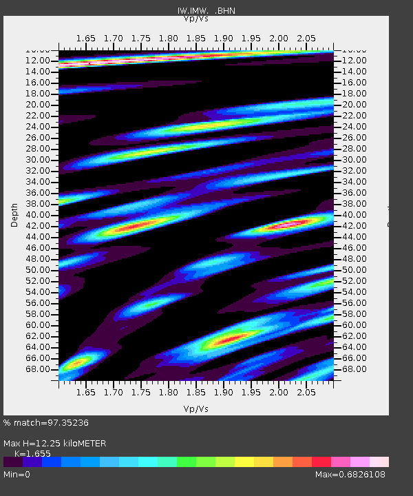
| Estimated Moho Depth: |
12.25 km |
| Estimated Crust Vp/Vs: |
1.65 |
| Assumed Crust Vp: |
6.207 km/s |
| Estimated Crust Vs: |
3.75 km/s |
| Estimated Crust Poisson's Ratio: |
0.21 |
|
| Radial Match: |
97.35236 % |
| Radial Bump: |
400 |
| Transverse Match: |
90.316795 % |
| Transverse Bump: |
400 |
| SOD ConfigId: |
410809 |
| Insert Time: |
2012-01-06 06:37:02.910 +0000 |
| GWidth: |
2.5 |
| Max Bumps: |
400 |
| Tol: |
0.001 |
|
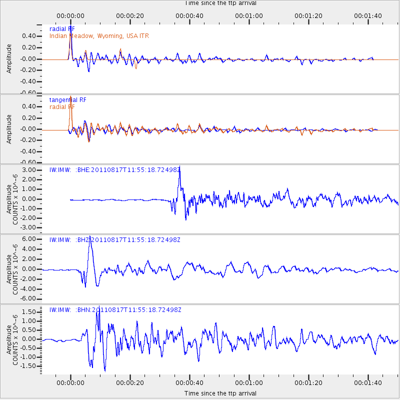
Signal To Noise
| Channel | StoN | STA | LTA |
| IW:IMW: :BHZ:20110817T11:55:18.72498Z | 13.76573 | 8.239902E-7 | 5.985808E-8 |
| IW:IMW: :BHN:20110817T11:55:18.72498Z | 3.192175 | 1.4141776E-7 | 4.4301384E-8 |
| IW:IMW: :BHE:20110817T11:55:18.72498Z | 8.86987 | 2.9822266E-7 | 3.3621987E-8 |
| Arrivals |
| Ps | 1.3 SECOND |
| PpPs | 5.1 SECOND |
| PsPs/PpSs | 6.4 SECOND |


