You are here: Home > Network List > G - GEOSCOPE Stations List
> Station DRV Dumont d'Urville, Terre Adelie (Antartica) > Earthquake Result Viewer
DRV Dumont d'Urville, Terre Adelie (Antartica) - Earthquake Result Viewer
| Earthquake location: |
Halmahera, Indonesia |
| Earthquake latitude/longitude: |
-1.2/127.9 |
| Earthquake time(UTC): |
1994/10/13 (286) 05:04:28 GMT |
| Earthquake Depth: |
33 km |
| Earthquake Magnitude: |
6.0 MB, 6.4 MS, 6.5 UNKNOWN, 6.4 MW |
| Earthquake Catalog/Contributor: |
WHDF/NEIC |
|
| Network: |
G GEOSCOPE |
| Station: |
DRV Dumont d'Urville, Terre Adelie (Antartica) |
| Lat/Lon: |
66.67 S/140.01 E |
| Elevation: |
40 m |
|
| Distance: |
65.8 deg |
| Az: |
174.765 deg |
| Baz: |
346.762 deg |
| Ray Param: |
0.057954837 |
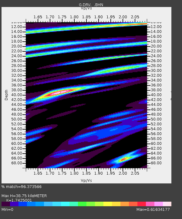
| Estimated Moho Depth: |
38.75 km |
| Estimated Crust Vp/Vs: |
1.74 |
| Assumed Crust Vp: |
6.39 km/s |
| Estimated Crust Vs: |
3.667 km/s |
| Estimated Crust Poisson's Ratio: |
0.25 |
|
| Radial Match: |
96.373566 % |
| Radial Bump: |
400 |
| Transverse Match: |
90.06821 % |
| Transverse Bump: |
400 |
| SOD ConfigId: |
4480 |
| Insert Time: |
2010-02-26 22:04:44.447 +0000 |
| GWidth: |
2.5 |
| Max Bumps: |
400 |
| Tol: |
0.001 |
|
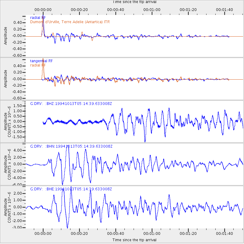
Signal To Noise
| Channel | StoN | STA | LTA |
| G:DRV: :BHN:19941013T05:14:39.633008Z | 3.5945518 | 7.0667664E-7 | 1.965966E-7 |
| G:DRV: :BHE:19941013T05:14:39.633008Z | 3.2418368 | 3.693138E-7 | 1.1392116E-7 |
| G:DRV: :BHZ:19941013T05:14:39.633008Z | 0.78438205 | 1.0766974E-7 | 1.3726695E-7 |
| Arrivals |
| Ps | 4.7 SECOND |
| PpPs | 16 SECOND |
| PsPs/PpSs | 21 SECOND |


