You are here: Home > Network List > TA - USArray Transportable Network (new EarthScope stations) Stations List
> Station L44A Lake County Forest Preserve, Grayslake, IL, USA > Earthquake Result Viewer
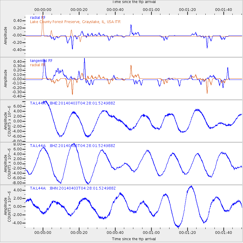
L44A Lake County Forest Preserve, Grayslake, IL, USA - Earthquake Result Viewer
*The percent match for this event was below the threshold and hence no stack was calculated.
| Earthquake location: |
Near Coast Of Northern Chile |
| Earthquake latitude/longitude: |
-20.6/-70.7 |
| Earthquake time(UTC): |
2014/04/03 (093) 04:17:57 GMT |
| Earthquake Depth: |
18 km |
| Earthquake Magnitude: |
5.2 mb |
| Earthquake Catalog/Contributor: |
ISC/ISC |
|
| Network: |
TA USArray Transportable Network (new EarthScope stations) |
| Station: |
L44A Lake County Forest Preserve, Grayslake, IL, USA |
| Lat/Lon: |
42.18 N/87.91 W |
| Elevation: |
202 m |
|
| Distance: |
64.4 deg |
| Az: |
345.907 deg |
| Baz: |
162.127 deg |
| Ray Param: |
$rayparam |
*The percent match for this event was below the threshold and hence was not used in the summary stack. |
|
| Radial Match: |
73.01828 % |
| Radial Bump: |
400 |
| Transverse Match: |
50.023243 % |
| Transverse Bump: |
400 |
| SOD ConfigId: |
3390531 |
| Insert Time: |
2019-04-11 02:36:24.449 +0000 |
| GWidth: |
2.5 |
| Max Bumps: |
400 |
| Tol: |
0.001 |
|
Signal To Noise
| Channel | StoN | STA | LTA |
| TA:L44A: :BHZ:20140403T04:28:01.524988Z | 2.731982 | 5.696377E-6 | 2.0850712E-6 |
| TA:L44A: :BHN:20140403T04:28:01.524988Z | 0.747294 | 1.2213393E-6 | 1.634349E-6 |
| TA:L44A: :BHE:20140403T04:28:01.524988Z | 0.66620684 | 2.9510172E-6 | 4.429581E-6 |
| Arrivals |
| Ps | |
| PpPs | |
| PsPs/PpSs | |


