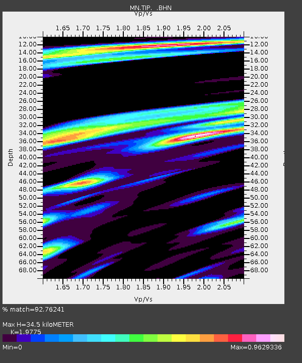
TIP Timpagrande, Italy - Earthquake Result Viewer
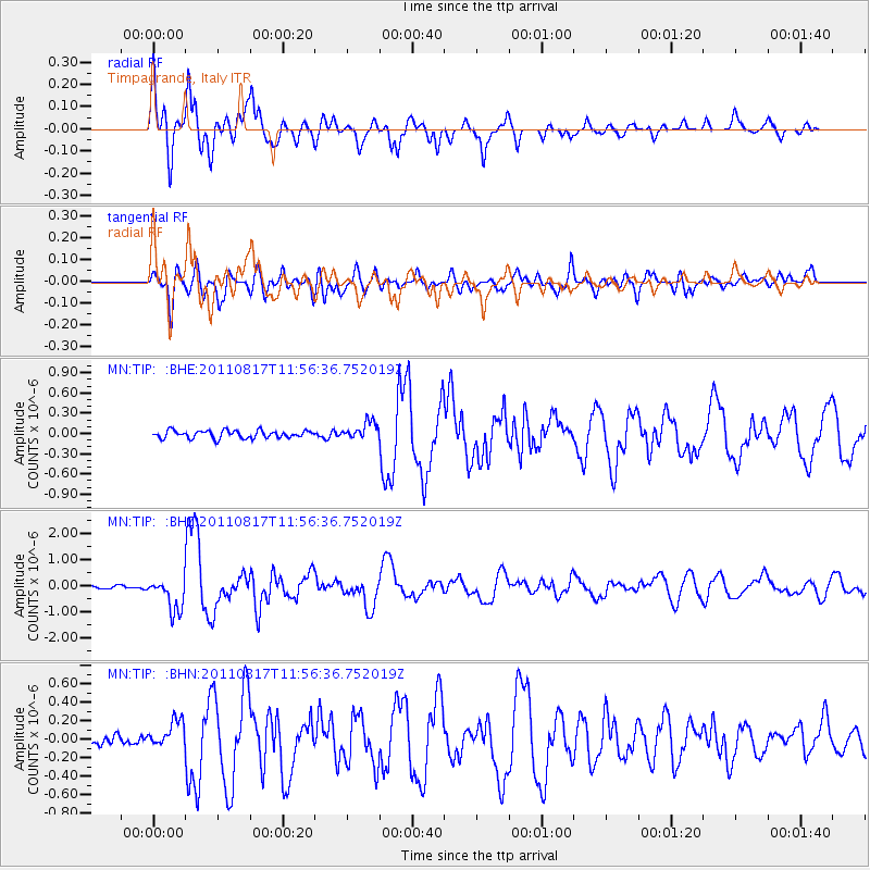
Earthquake location: Off East Coast Of Honshu, Japan
Earthquake latitude/longitude: 36.8/143.8
Earthquake time(UTC): 2011/08/17 (229) 11:44:08 GMT
Earthquake Depth: 9.0 km
Earthquake Magnitude: 6.1 MB, 5.8 MS, 6.2 MW, 6.1 MW
Earthquake Catalog/Contributor: WHDF/NEIC
Network: MN MEDNET Project
Station: TIP Timpagrande, Italy
Lat/Lon: 39.18 N/16.76 E
Elevation: 789 m
Distance: 90.0 deg
Az: 321.637 deg
Baz: 39.883 deg
Ray Param: 0.041701727
Estimated Moho Depth: 34.5 km
Estimated Crust Vp/Vs: 1.98
Assumed Crust Vp: 6.1 km/s
Estimated Crust Vs: 3.085 km/s
Estimated Crust Poisson's Ratio: 0.33
Radial Match: 92.76241 %
Radial Bump: 400
Transverse Match: 88.044655 %
Transverse Bump: 400
SOD ConfigId: 410809
Insert Time: 2012-01-06 06:40:36.539 +0000
GWidth: 2.5
Max Bumps: 400
Tol: 0.001

Signal To Noise

ChannelStoNSTALTA
MN:TIP: :BHZ:20110817T11:56:36.752019Z12.29686456.396101E-75.2014084E-8
MN:TIP: :BHN:20110817T11:56:36.752019Z3.7773851.4384558E-73.808073E-8
MN:TIP: :BHE:20110817T11:56:36.752019Z2.26159761.2812143E-75.6650855E-8
Arrivals
Ps5.6 SECOND
PpPs17 SECOND
PsPs/PpSs22 SECOND