You are here: Home > Network List > TA - USArray Transportable Network (new EarthScope stations) Stations List
> Station Q53A Leroy, WV, USA > Earthquake Result Viewer
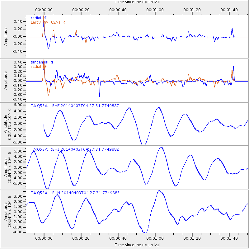
Q53A Leroy, WV, USA - Earthquake Result Viewer
*The percent match for this event was below the threshold and hence no stack was calculated.
| Earthquake location: |
Near Coast Of Northern Chile |
| Earthquake latitude/longitude: |
-20.6/-70.7 |
| Earthquake time(UTC): |
2014/04/03 (093) 04:17:57 GMT |
| Earthquake Depth: |
18 km |
| Earthquake Magnitude: |
5.2 mb |
| Earthquake Catalog/Contributor: |
ISC/ISC |
|
| Network: |
TA USArray Transportable Network (new EarthScope stations) |
| Station: |
Q53A Leroy, WV, USA |
| Lat/Lon: |
38.86 N/81.53 W |
| Elevation: |
310 m |
|
| Distance: |
60.0 deg |
| Az: |
350.271 deg |
| Baz: |
168.3 deg |
| Ray Param: |
$rayparam |
*The percent match for this event was below the threshold and hence was not used in the summary stack. |
|
| Radial Match: |
68.06876 % |
| Radial Bump: |
400 |
| Transverse Match: |
57.44396 % |
| Transverse Bump: |
400 |
| SOD ConfigId: |
3390531 |
| Insert Time: |
2019-04-11 02:36:48.253 +0000 |
| GWidth: |
2.5 |
| Max Bumps: |
400 |
| Tol: |
0.001 |
|
Signal To Noise
| Channel | StoN | STA | LTA |
| TA:Q53A: :BHZ:20140403T04:27:31.774988Z | 2.0556045 | 6.1013766E-6 | 2.9681667E-6 |
| TA:Q53A: :BHN:20140403T04:27:31.774988Z | 0.74825567 | 1.2980269E-6 | 1.734737E-6 |
| TA:Q53A: :BHE:20140403T04:27:31.774988Z | 0.28739977 | 8.50592E-7 | 2.9596129E-6 |
| Arrivals |
| Ps | |
| PpPs | |
| PsPs/PpSs | |


