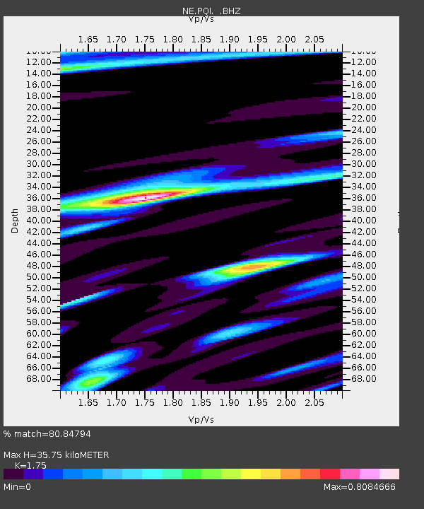
PQI Presque Isle, ME - Earthquake Result Viewer

Earthquake location: Off East Coast Of Honshu, Japan
Earthquake latitude/longitude: 36.8/143.8
Earthquake time(UTC): 2011/08/17 (229) 11:44:08 GMT
Earthquake Depth: 9.0 km
Earthquake Magnitude: 6.1 MB, 5.8 MS, 6.2 MW, 6.1 MW
Earthquake Catalog/Contributor: WHDF/NEIC
Network: NE New England Seismic Network
Station: PQI Presque Isle, ME
Lat/Lon: 46.67 N/68.01 W
Elevation: 175 m
Distance: 92.2 deg
Az: 21.283 deg
Baz: 334.959 deg
Ray Param: 0.04149855
Estimated Moho Depth: 35.75 km
Estimated Crust Vp/Vs: 1.75
Assumed Crust Vp: 6.419 km/s
Estimated Crust Vs: 3.668 km/s
Estimated Crust Poisson's Ratio: 0.26
Radial Match: 80.84794 %
Radial Bump: 375
Transverse Match: 64.98718 %
Transverse Bump: 400
SOD ConfigId: 410809
Insert Time: 2012-01-06 06:41:34.547 +0000
GWidth: 2.5
Max Bumps: 400
Tol: 0.001

Signal To Noise

ChannelStoNSTALTA
NE:PQI: :BHZ:20110817T11:56:46.614995Z4.952461.2279314E-62.4794375E-7
NE:PQI: :BHN:20110817T11:56:46.614995Z1.51894692.808244E-71.8488097E-7
NE:PQI: :BHE:20110817T11:56:46.614995Z0.73705141.015188E-71.3773638E-7
Arrivals
Ps4.3 SECOND
PpPs15 SECOND
PsPs/PpSs19 SECOND