M04C Macdoel, CA, USA - Earthquake Result Viewer
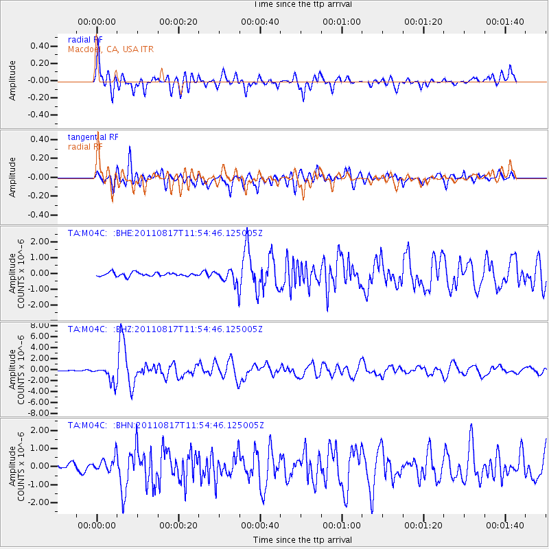
Earthquake location: Off East Coast Of Honshu, Japan
Earthquake latitude/longitude: 36.8/143.8
Earthquake time(UTC): 2011/08/17 (229) 11:44:08 GMT
Earthquake Depth: 9.0 km
Earthquake Magnitude: 6.1 MB, 5.8 MS, 6.2 MW, 6.1 MW
Earthquake Catalog/Contributor: WHDF/NEIC
Network: TA USArray Transportable Network (new EarthScope stations)
Station: M04C Macdoel, CA, USA
Lat/Lon: 41.78 N/121.84 W
Elevation: 1391 m
Distance: 69.5 deg
Az: 52.744 deg
Baz: 301.285 deg
Ray Param: 0.05558481
Estimated Moho Depth: 60.25 km
Estimated Crust Vp/Vs: 1.65
Assumed Crust Vp: 6.566 km/s
Estimated Crust Vs: 3.973 km/s
Estimated Crust Poisson's Ratio: 0.21
Radial Match: 85.78396 %
Radial Bump: 400
Transverse Match: 82.2969 %
Transverse Bump: 400
SOD ConfigId: 410809
Insert Time: 2012-01-06 06:43:26.486 +0000
GWidth: 2.5
Max Bumps: 400
Tol: 0.001

Signal To Noise

ChannelStoNSTALTA
TA:M04C: :BHZ:20110817T11:54:46.125005Z19.9403081.5901663E-67.9746336E-8
TA:M04C: :BHN:20110817T11:54:46.125005Z2.02289414.172294E-72.062537E-7
TA:M04C: :BHE:20110817T11:54:46.125005Z4.7478225.518786E-71.1623826E-7
Arrivals
Ps6.2 SECOND
PpPs23 SECOND
PsPs/PpSs30 SECOND