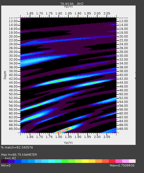
W18A Petrified Forest, AZ, USA - Earthquake Result Viewer

Earthquake location: Off East Coast Of Honshu, Japan
Earthquake latitude/longitude: 36.8/143.8
Earthquake time(UTC): 2011/08/17 (229) 11:44:08 GMT
Earthquake Depth: 9.0 km
Earthquake Magnitude: 6.1 MB, 5.8 MS, 6.2 MW, 6.1 MW
Earthquake Catalog/Contributor: WHDF/NEIC
Network: TA USArray Transportable Network (new EarthScope stations)
Station: W18A Petrified Forest, AZ, USA
Lat/Lon: 35.12 N/109.74 W
Elevation: 1750 m
Distance: 81.1 deg
Az: 52.71 deg
Baz: 308.802 deg
Ray Param: 0.047812756
Estimated Moho Depth: 68.75 km
Estimated Crust Vp/Vs: 1.82
Assumed Crust Vp: 6.496 km/s
Estimated Crust Vs: 3.569 km/s
Estimated Crust Poisson's Ratio: 0.28
Radial Match: 92.340576 %
Radial Bump: 400
Transverse Match: 81.61069 %
Transverse Bump: 400
SOD ConfigId: 410809
Insert Time: 2012-01-06 06:43:40.770 +0000
GWidth: 2.5
Max Bumps: 400
Tol: 0.001

Signal To Noise

ChannelStoNSTALTA
TA:W18A: :BHZ:20110817T11:55:52.549993Z16.5074771.2074651E-67.314655E-8
TA:W18A: :BHN:20110817T11:55:52.549993Z2.5763451.8309788E-77.1068854E-8
TA:W18A: :BHE:20110817T11:55:52.549993Z5.6347493.5879225E-76.367493E-8
Arrivals
Ps8.9 SECOND
PpPs29 SECOND
PsPs/PpSs38 SECOND