MSTX Muleshoe, TX, USA - Earthquake Result Viewer
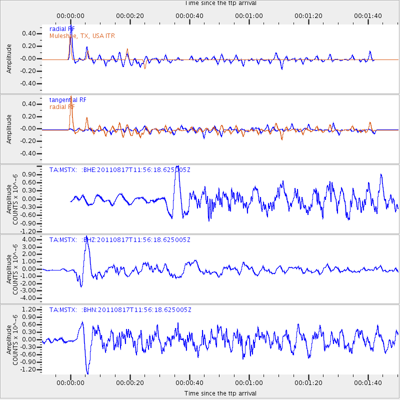
Earthquake location: Off East Coast Of Honshu, Japan
Earthquake latitude/longitude: 36.8/143.8
Earthquake time(UTC): 2011/08/17 (229) 11:44:08 GMT
Earthquake Depth: 9.0 km
Earthquake Magnitude: 6.1 MB, 5.8 MS, 6.2 MW, 6.1 MW
Earthquake Catalog/Contributor: WHDF/NEIC
Network: TA USArray Transportable Network (new EarthScope stations)
Station: MSTX Muleshoe, TX, USA
Lat/Lon: 33.97 N/102.77 W
Elevation: 1167 m
Distance: 86.2 deg
Az: 49.822 deg
Baz: 312.417 deg
Ray Param: 0.0442031
Estimated Moho Depth: 42.75 km
Estimated Crust Vp/Vs: 1.78
Assumed Crust Vp: 6.129 km/s
Estimated Crust Vs: 3.448 km/s
Estimated Crust Poisson's Ratio: 0.27
Radial Match: 89.70247 %
Radial Bump: 400
Transverse Match: 76.59518 %
Transverse Bump: 400
SOD ConfigId: 410809
Insert Time: 2012-01-06 06:44:19.911 +0000
GWidth: 2.5
Max Bumps: 400
Tol: 0.001

Signal To Noise

ChannelStoNSTALTA
TA:MSTX: :BHZ:20110817T11:56:18.625005Z12.0725611.1286628E-69.348992E-8
TA:MSTX: :BHN:20110817T11:56:18.625005Z3.38167523.19397E-79.444935E-8
TA:MSTX: :BHE:20110817T11:56:18.625005Z2.83272653.1833522E-71.12377684E-7
Arrivals
Ps5.5 SECOND
PpPs19 SECOND
PsPs/PpSs25 SECOND