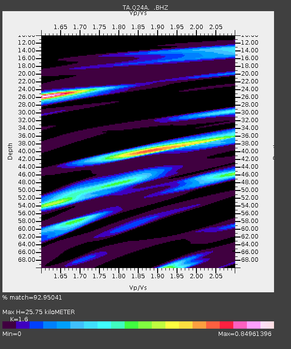
Q24A Divide, CO, USA - Earthquake Result Viewer
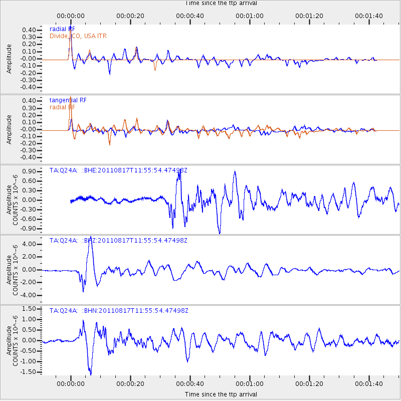
Earthquake location: Off East Coast Of Honshu, Japan
Earthquake latitude/longitude: 36.8/143.8
Earthquake time(UTC): 2011/08/17 (229) 11:44:08 GMT
Earthquake Depth: 9.0 km
Earthquake Magnitude: 6.1 MB, 5.8 MS, 6.2 MW, 6.1 MW
Earthquake Catalog/Contributor: WHDF/NEIC
Network: TA USArray Transportable Network (new EarthScope stations)
Station: Q24A Divide, CO, USA
Lat/Lon: 38.96 N/105.15 W
Elevation: 2775 m
Distance: 81.5 deg
Az: 47.352 deg
Baz: 310.745 deg
Ray Param: 0.047555022
Estimated Moho Depth: 25.75 km
Estimated Crust Vp/Vs: 1.60
Assumed Crust Vp: 6.159 km/s
Estimated Crust Vs: 3.849 km/s
Estimated Crust Poisson's Ratio: 0.18
Radial Match: 92.95041 %
Radial Bump: 400
Transverse Match: 87.06382 %
Transverse Bump: 400
SOD ConfigId: 410809
Insert Time: 2012-01-06 06:44:34.433 +0000
GWidth: 2.5
Max Bumps: 400
Tol: 0.001

Signal To Noise

ChannelStoNSTALTA
TA:Q24A: :BHZ:20110817T11:55:54.47498Z22.7612861.1067149E-64.8622685E-8
TA:Q24A: :BHN:20110817T11:55:54.47498Z8.6746913.57295E-74.1188212E-8
TA:Q24A: :BHE:20110817T11:55:54.47498Z5.2521162.8728985E-75.469983E-8
Arrivals
Ps2.6 SECOND
PpPs11 SECOND
PsPs/PpSs13 SECOND